You are here: Home > Network List > US - United States National Seismic Network Stations List
> Station HAWA Hanford, Washington, USA > Earthquake Result Viewer
HAWA Hanford, Washington, USA - Earthquake Result Viewer
*The percent match for this event was below the threshold and hence no stack was calculated.
| Earthquake location: |
North Korea |
| Earthquake latitude/longitude: |
41.3/129.0 |
| Earthquake time(UTC): |
2017/09/03 (246) 03:30:01 GMT |
| Earthquake Depth: |
0.0 km |
| Earthquake Magnitude: |
6.3 mb |
| Earthquake Catalog/Contributor: |
NEIC PDE/us |
|
| Network: |
US United States National Seismic Network |
| Station: |
HAWA Hanford, Washington, USA |
| Lat/Lon: |
46.39 N/119.53 W |
| Elevation: |
364 m |
|
| Distance: |
73.5 deg |
| Az: |
42.226 deg |
| Baz: |
313.019 deg |
| Ray Param: |
$rayparam |
*The percent match for this event was below the threshold and hence was not used in the summary stack. |
|
| Radial Match: |
60.311974 % |
| Radial Bump: |
400 |
| Transverse Match: |
52.92253 % |
| Transverse Bump: |
400 |
| SOD ConfigId: |
2307692 |
| Insert Time: |
2017-09-17 03:37:41.998 +0000 |
| GWidth: |
2.5 |
| Max Bumps: |
400 |
| Tol: |
0.001 |
|
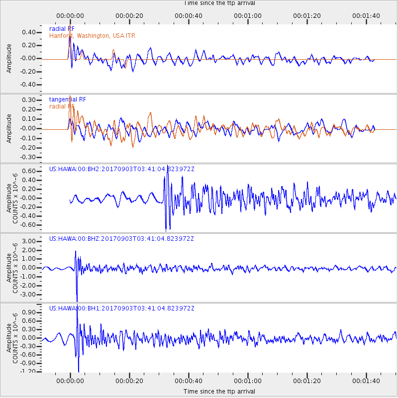
Signal To Noise
| Channel | StoN | STA | LTA |
| US:HAWA:00:BHZ:20170903T03:41:04.823972Z | 7.63498 | 9.940782E-7 | 1.302005E-7 |
| US:HAWA:00:BH1:20170903T03:41:04.823972Z | 3.5973525 | 4.3109782E-7 | 1.1983752E-7 |
| US:HAWA:00:BH2:20170903T03:41:04.823972Z | 4.9210644 | 3.3046516E-7 | 6.715319E-8 |
| Arrivals |
| Ps | |
| PpPs | |
| PsPs/PpSs | |


