You are here: Home > Network List > N4 - Central and EAstern US Network Stations List
> Station P61A Hammonton, NJ, USA > Earthquake Result Viewer
P61A Hammonton, NJ, USA - Earthquake Result Viewer
| Earthquake location: |
South Of Alaska |
| Earthquake latitude/longitude: |
54.7/-159.6 |
| Earthquake time(UTC): |
2020/10/19 (293) 20:54:40 GMT |
| Earthquake Depth: |
41 km |
| Earthquake Magnitude: |
7.4 Mi |
| Earthquake Catalog/Contributor: |
NEIC PDE/at |
|
| Network: |
N4 Central and EAstern US Network |
| Station: |
P61A Hammonton, NJ, USA |
| Lat/Lon: |
39.67 N/74.79 W |
| Elevation: |
22 m |
|
| Distance: |
56.1 deg |
| Az: |
67.866 deg |
| Baz: |
315.794 deg |
| Ray Param: |
0.06430106 |
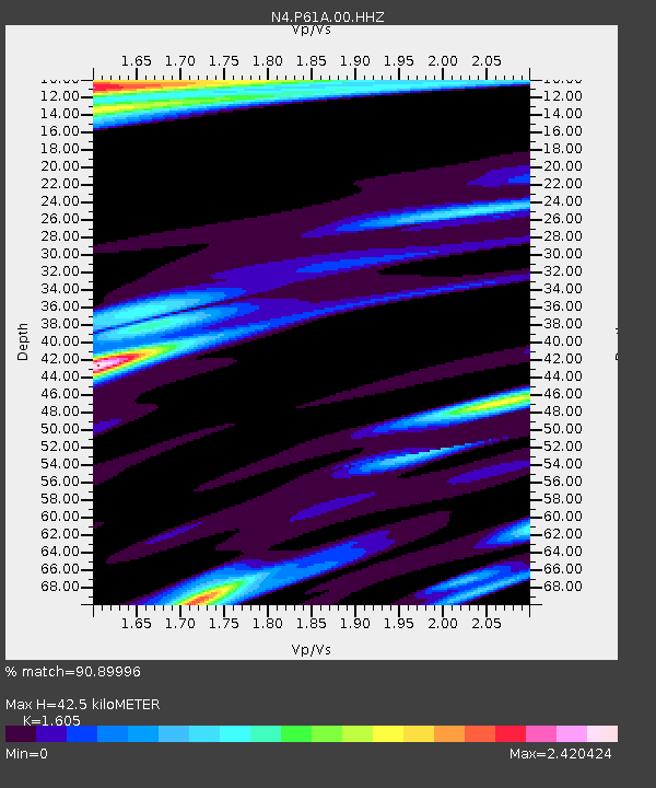
| Estimated Moho Depth: |
42.5 km |
| Estimated Crust Vp/Vs: |
1.61 |
| Assumed Crust Vp: |
6.287 km/s |
| Estimated Crust Vs: |
3.917 km/s |
| Estimated Crust Poisson's Ratio: |
0.18 |
|
| Radial Match: |
90.89996 % |
| Radial Bump: |
367 |
| Transverse Match: |
78.40269 % |
| Transverse Bump: |
400 |
| SOD ConfigId: |
22732711 |
| Insert Time: |
2020-11-02 21:11:13.077 +0000 |
| GWidth: |
2.5 |
| Max Bumps: |
400 |
| Tol: |
0.001 |
|

Signal To Noise
| Channel | StoN | STA | LTA |
| N4:P61A:00:HHZ:20201019T21:03:44.320007Z | 6.7034464 | 2.8960546E-6 | 4.3202476E-7 |
| N4:P61A:00:HH1:20201019T21:03:44.320007Z | 2.282812 | 1.883086E-6 | 8.2489754E-7 |
| N4:P61A:00:HH2:20201019T21:03:44.320007Z | 1.9097933 | 1.8483578E-6 | 9.678314E-7 |
| Arrivals |
| Ps | 4.3 SECOND |
| PpPs | 17 SECOND |
| PsPs/PpSs | 21 SECOND |


