You are here: Home > Network List > N4 - Central and EAstern US Network Stations List
> Station W52A Murphy, NC, USA > Earthquake Result Viewer
W52A Murphy, NC, USA - Earthquake Result Viewer
| Earthquake location: |
South Of Alaska |
| Earthquake latitude/longitude: |
54.7/-159.6 |
| Earthquake time(UTC): |
2020/10/19 (293) 20:54:40 GMT |
| Earthquake Depth: |
41 km |
| Earthquake Magnitude: |
7.4 Mi |
| Earthquake Catalog/Contributor: |
NEIC PDE/at |
|
| Network: |
N4 Central and EAstern US Network |
| Station: |
W52A Murphy, NC, USA |
| Lat/Lon: |
35.09 N/83.93 W |
| Elevation: |
519 m |
|
| Distance: |
54.3 deg |
| Az: |
78.102 deg |
| Baz: |
316.114 deg |
| Ray Param: |
0.06546607 |
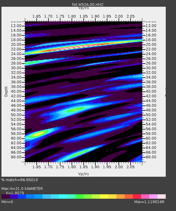
| Estimated Moho Depth: |
21.0 km |
| Estimated Crust Vp/Vs: |
1.81 |
| Assumed Crust Vp: |
6.35 km/s |
| Estimated Crust Vs: |
3.513 km/s |
| Estimated Crust Poisson's Ratio: |
0.28 |
|
| Radial Match: |
96.85018 % |
| Radial Bump: |
400 |
| Transverse Match: |
83.730644 % |
| Transverse Bump: |
400 |
| SOD ConfigId: |
22732711 |
| Insert Time: |
2020-11-02 21:12:06.422 +0000 |
| GWidth: |
2.5 |
| Max Bumps: |
400 |
| Tol: |
0.001 |
|

Signal To Noise
| Channel | StoN | STA | LTA |
| N4:W52A:00:HHZ:20201019T21:03:31.469971Z | 6.0976973 | 1.7889761E-6 | 2.9338554E-7 |
| N4:W52A:00:HH1:20201019T21:03:31.469971Z | 3.229202 | 6.737954E-7 | 2.0865693E-7 |
| N4:W52A:00:HH2:20201019T21:03:31.469971Z | 3.6564705 | 7.841771E-7 | 2.1446284E-7 |
| Arrivals |
| Ps | 2.8 SECOND |
| PpPs | 8.8 SECOND |
| PsPs/PpSs | 12 SECOND |


