You are here: Home > Network List > US - United States National Seismic Network Stations List
> Station MNTX Cornudas Mountains, Texas, USA > Earthquake Result Viewer
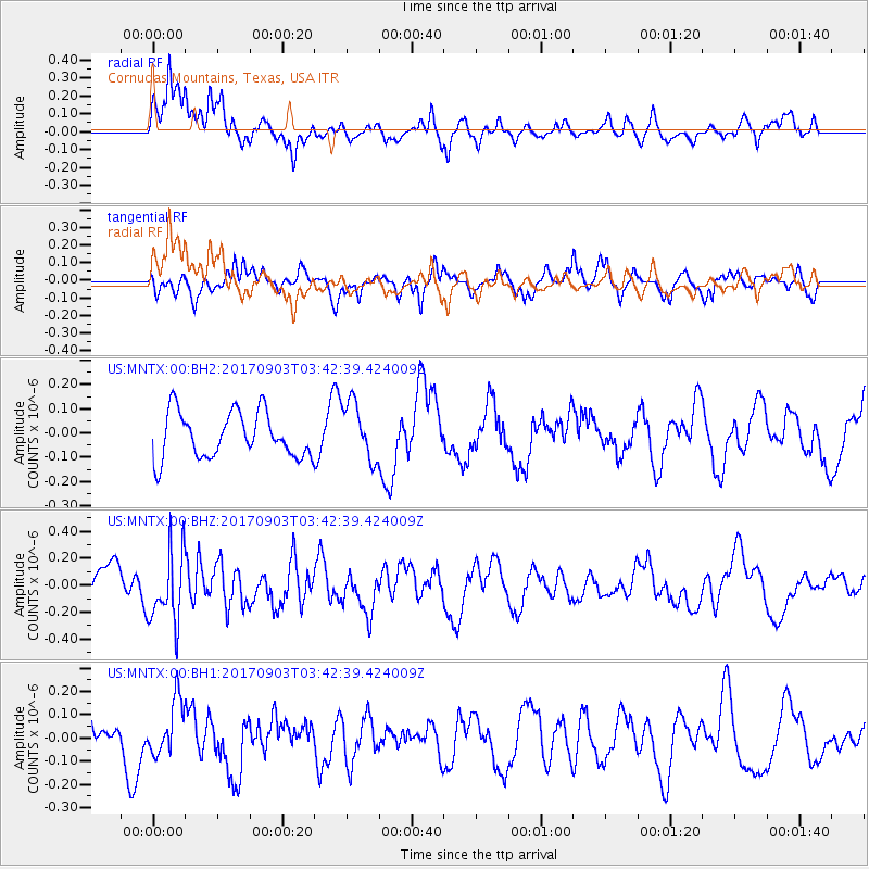
MNTX Cornudas Mountains, Texas, USA - Earthquake Result Viewer
*The percent match for this event was below the threshold and hence no stack was calculated.
| Earthquake location: |
North Korea |
| Earthquake latitude/longitude: |
41.3/129.0 |
| Earthquake time(UTC): |
2017/09/03 (246) 03:30:01 GMT |
| Earthquake Depth: |
0.0 km |
| Earthquake Magnitude: |
6.3 mb |
| Earthquake Catalog/Contributor: |
NEIC PDE/us |
|
| Network: |
US United States National Seismic Network |
| Station: |
MNTX Cornudas Mountains, Texas, USA |
| Lat/Lon: |
31.70 N/105.38 W |
| Elevation: |
404 m |
|
| Distance: |
91.7 deg |
| Az: |
43.911 deg |
| Baz: |
322.219 deg |
| Ray Param: |
$rayparam |
*The percent match for this event was below the threshold and hence was not used in the summary stack. |
|
| Radial Match: |
68.254 % |
| Radial Bump: |
400 |
| Transverse Match: |
59.59059 % |
| Transverse Bump: |
400 |
| SOD ConfigId: |
2307692 |
| Insert Time: |
2017-09-17 03:37:59.203 +0000 |
| GWidth: |
2.5 |
| Max Bumps: |
400 |
| Tol: |
0.001 |
|
Signal To Noise
| Channel | StoN | STA | LTA |
| US:MNTX:00:BHZ:20170903T03:42:39.424009Z | 2.147635 | 2.6265508E-7 | 1.2229968E-7 |
| US:MNTX:00:BH1:20170903T03:42:39.424009Z | 1.0997285 | 1.1652951E-7 | 1.0596207E-7 |
| US:MNTX:00:BH2:20170903T03:42:39.424009Z | 1.2736621 | 1.1937236E-7 | 9.372372E-8 |
| Arrivals |
| Ps | |
| PpPs | |
| PsPs/PpSs | |


