You are here: Home > Network List > NM - Cooperative New Madrid Seismic Network Stations List
> Station CLTN Cedars of Lebanon,TN > Earthquake Result Viewer
CLTN Cedars of Lebanon,TN - Earthquake Result Viewer
| Earthquake location: |
South Of Alaska |
| Earthquake latitude/longitude: |
54.7/-159.6 |
| Earthquake time(UTC): |
2020/10/19 (293) 20:54:40 GMT |
| Earthquake Depth: |
41 km |
| Earthquake Magnitude: |
7.4 Mi |
| Earthquake Catalog/Contributor: |
NEIC PDE/at |
|
| Network: |
NM Cooperative New Madrid Seismic Network |
| Station: |
CLTN Cedars of Lebanon,TN |
| Lat/Lon: |
36.09 N/86.33 W |
| Elevation: |
208 m |
|
| Distance: |
52.2 deg |
| Az: |
78.984 deg |
| Baz: |
315.249 deg |
| Ray Param: |
0.066811055 |
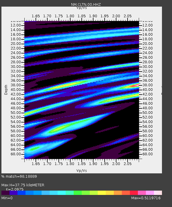
| Estimated Moho Depth: |
37.75 km |
| Estimated Crust Vp/Vs: |
2.10 |
| Assumed Crust Vp: |
6.444 km/s |
| Estimated Crust Vs: |
3.072 km/s |
| Estimated Crust Poisson's Ratio: |
0.35 |
|
| Radial Match: |
98.18889 % |
| Radial Bump: |
289 |
| Transverse Match: |
93.77866 % |
| Transverse Bump: |
400 |
| SOD ConfigId: |
22732711 |
| Insert Time: |
2020-11-02 21:12:40.228 +0000 |
| GWidth: |
2.5 |
| Max Bumps: |
400 |
| Tol: |
0.001 |
|

Signal To Noise
| Channel | StoN | STA | LTA |
| NM:CLTN:00:HHZ:20201019T21:03:16.210022Z | 19.697416 | 1.9254874E-6 | 9.77533E-8 |
| NM:CLTN:00:HHN:20201019T21:03:16.210022Z | 9.600973 | 6.918521E-7 | 7.206062E-8 |
| NM:CLTN:00:HHE:20201019T21:03:16.210022Z | 8.335942 | 5.8968413E-7 | 7.073996E-8 |
| Arrivals |
| Ps | 6.7 SECOND |
| PpPs | 17 SECOND |
| PsPs/PpSs | 24 SECOND |


