You are here: Home > Network List > NN - Western Great Basin/Eastern Sierra Nevada Stations List
> Station LCH Last Chance Range, CA. (GPS 01/04/2001) w84 > Earthquake Result Viewer
LCH Last Chance Range, CA. (GPS 01/04/2001) w84 - Earthquake Result Viewer
| Earthquake location: |
South Of Alaska |
| Earthquake latitude/longitude: |
54.7/-159.6 |
| Earthquake time(UTC): |
2020/10/19 (293) 20:54:40 GMT |
| Earthquake Depth: |
41 km |
| Earthquake Magnitude: |
7.4 Mi |
| Earthquake Catalog/Contributor: |
NEIC PDE/at |
|
| Network: |
NN Western Great Basin/Eastern Sierra Nevada |
| Station: |
LCH Last Chance Range, CA. (GPS 01/04/2001) w84 |
| Lat/Lon: |
37.23 N/117.65 W |
| Elevation: |
1414 m |
|
| Distance: |
33.4 deg |
| Az: |
104.0 deg |
| Baz: |
315.069 deg |
| Ray Param: |
0.07817837 |
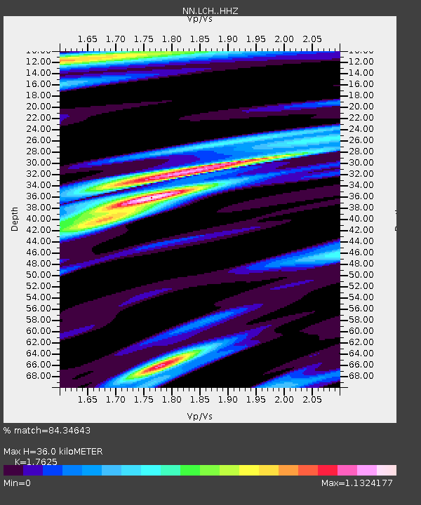
| Estimated Moho Depth: |
36.0 km |
| Estimated Crust Vp/Vs: |
1.76 |
| Assumed Crust Vp: |
6.279 km/s |
| Estimated Crust Vs: |
3.562 km/s |
| Estimated Crust Poisson's Ratio: |
0.26 |
|
| Radial Match: |
84.34643 % |
| Radial Bump: |
371 |
| Transverse Match: |
84.46078 % |
| Transverse Bump: |
387 |
| SOD ConfigId: |
22732711 |
| Insert Time: |
2020-11-02 21:13:18.246 +0000 |
| GWidth: |
2.5 |
| Max Bumps: |
400 |
| Tol: |
0.001 |
|

Signal To Noise
| Channel | StoN | STA | LTA |
| NN:LCH: :HHZ:20201019T21:00:44.048004Z | 2.567488 | 5.152716E-7 | 2.0069095E-7 |
| NN:LCH: :HHN:20201019T21:00:44.048004Z | 2.4074628 | 4.227195E-7 | 1.7558712E-7 |
| NN:LCH: :HHE:20201019T21:00:44.048004Z | 1.3781332 | 1.7188547E-7 | 1.2472341E-7 |
| Arrivals |
| Ps | 4.7 SECOND |
| PpPs | 15 SECOND |
| PsPs/PpSs | 19 SECOND |


