You are here: Home > Network List > NN - Western Great Basin/Eastern Sierra Nevada Stations List
> Station YER Yerington, Nevada w84gm > Earthquake Result Viewer
YER Yerington, Nevada w84gm - Earthquake Result Viewer
| Earthquake location: |
South Of Alaska |
| Earthquake latitude/longitude: |
54.7/-159.6 |
| Earthquake time(UTC): |
2020/10/19 (293) 20:54:40 GMT |
| Earthquake Depth: |
41 km |
| Earthquake Magnitude: |
7.4 Mi |
| Earthquake Catalog/Contributor: |
NEIC PDE/at |
|
| Network: |
NN Western Great Basin/Eastern Sierra Nevada |
| Station: |
YER Yerington, Nevada w84gm |
| Lat/Lon: |
38.99 N/119.24 W |
| Elevation: |
1857 m |
|
| Distance: |
31.2 deg |
| Az: |
103.3 deg |
| Baz: |
313.497 deg |
| Ray Param: |
0.079082474 |
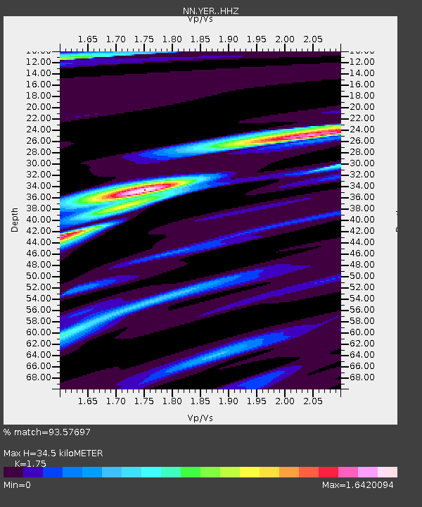
| Estimated Moho Depth: |
34.5 km |
| Estimated Crust Vp/Vs: |
1.75 |
| Assumed Crust Vp: |
6.279 km/s |
| Estimated Crust Vs: |
3.588 km/s |
| Estimated Crust Poisson's Ratio: |
0.26 |
|
| Radial Match: |
93.57697 % |
| Radial Bump: |
326 |
| Transverse Match: |
84.541756 % |
| Transverse Bump: |
400 |
| SOD ConfigId: |
22732711 |
| Insert Time: |
2020-11-02 21:13:45.305 +0000 |
| GWidth: |
2.5 |
| Max Bumps: |
400 |
| Tol: |
0.001 |
|

Signal To Noise
| Channel | StoN | STA | LTA |
| NN:YER: :HHZ:20201019T21:00:25.519012Z | 7.624966 | 8.1937975E-7 | 1.0746012E-7 |
| NN:YER: :HHN:20201019T21:00:25.519012Z | 4.024159 | 3.1984382E-7 | 7.9480905E-8 |
| NN:YER: :HHE:20201019T21:00:25.519012Z | 3.8208737 | 5.117866E-7 | 1.3394491E-7 |
| Arrivals |
| Ps | 4.5 SECOND |
| PpPs | 14 SECOND |
| PsPs/PpSs | 18 SECOND |


