You are here: Home > Network List > O2 - Oklahoma Consolidated Temporary Seismic Networks Stations List
> Station FW09 Waynoka, Oklahoma, USA > Earthquake Result Viewer
FW09 Waynoka, Oklahoma, USA - Earthquake Result Viewer
| Earthquake location: |
South Of Alaska |
| Earthquake latitude/longitude: |
54.7/-159.6 |
| Earthquake time(UTC): |
2020/10/19 (293) 20:54:40 GMT |
| Earthquake Depth: |
41 km |
| Earthquake Magnitude: |
7.4 Mi |
| Earthquake Catalog/Contributor: |
NEIC PDE/at |
|
| Network: |
O2 Oklahoma Consolidated Temporary Seismic Networks |
| Station: |
FW09 Waynoka, Oklahoma, USA |
| Lat/Lon: |
36.55 N/99.04 W |
| Elevation: |
517 m |
|
| Distance: |
44.6 deg |
| Az: |
88.171 deg |
| Baz: |
313.856 deg |
| Ray Param: |
0.071756385 |
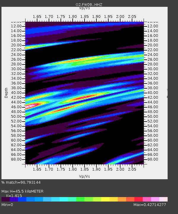
| Estimated Moho Depth: |
45.5 km |
| Estimated Crust Vp/Vs: |
1.62 |
| Assumed Crust Vp: |
6.426 km/s |
| Estimated Crust Vs: |
3.979 km/s |
| Estimated Crust Poisson's Ratio: |
0.19 |
|
| Radial Match: |
98.793144 % |
| Radial Bump: |
249 |
| Transverse Match: |
98.793144 % |
| Transverse Bump: |
249 |
| SOD ConfigId: |
22732711 |
| Insert Time: |
2020-11-02 21:14:33.753 +0000 |
| GWidth: |
2.5 |
| Max Bumps: |
400 |
| Tol: |
0.001 |
|

Signal To Noise
| Channel | StoN | STA | LTA |
| O2:FW09: :HHZ:20201019T21:02:17.415009Z | 10.498047 | 2.535216E-6 | 2.414941E-7 |
| $trig.getChannelId() | $trig.getValue() | $trig.getSTA() | $trig.getLTA() |
| O2:FW09: :HHE:20201019T21:02:17.415009Z | 4.5721216 | 1.0005958E-6 | 2.1884716E-7 |
| Arrivals |
| Ps | 4.7 SECOND |
| PpPs | 17 SECOND |
| PsPs/PpSs | 22 SECOND |


