You are here: Home > Network List > O2 - Oklahoma Consolidated Temporary Seismic Networks Stations List
> Station MRSH Marshall, Oklahoma, USA > Earthquake Result Viewer
MRSH Marshall, Oklahoma, USA - Earthquake Result Viewer
| Earthquake location: |
South Of Alaska |
| Earthquake latitude/longitude: |
54.7/-159.6 |
| Earthquake time(UTC): |
2020/10/19 (293) 20:54:40 GMT |
| Earthquake Depth: |
41 km |
| Earthquake Magnitude: |
7.4 Mi |
| Earthquake Catalog/Contributor: |
NEIC PDE/at |
|
| Network: |
O2 Oklahoma Consolidated Temporary Seismic Networks |
| Station: |
MRSH Marshall, Oklahoma, USA |
| Lat/Lon: |
36.13 N/97.70 W |
| Elevation: |
309 m |
|
| Distance: |
45.6 deg |
| Az: |
87.529 deg |
| Baz: |
314.196 deg |
| Ray Param: |
0.07105132 |
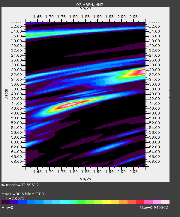
| Estimated Moho Depth: |
30.5 km |
| Estimated Crust Vp/Vs: |
2.10 |
| Assumed Crust Vp: |
6.483 km/s |
| Estimated Crust Vs: |
3.091 km/s |
| Estimated Crust Poisson's Ratio: |
0.35 |
|
| Radial Match: |
97.59612 % |
| Radial Bump: |
276 |
| Transverse Match: |
90.37269 % |
| Transverse Bump: |
393 |
| SOD ConfigId: |
22732711 |
| Insert Time: |
2020-11-02 21:14:41.758 +0000 |
| GWidth: |
2.5 |
| Max Bumps: |
400 |
| Tol: |
0.001 |
|

Signal To Noise
| Channel | StoN | STA | LTA |
| O2:MRSH: :HHZ:20201019T21:02:25.904999Z | 12.96521 | 1.8739534E-6 | 1.4453705E-7 |
| O2:MRSH: :HHN:20201019T21:02:25.904999Z | 3.6449013 | 6.674233E-7 | 1.8311148E-7 |
| O2:MRSH: :HHE:20201019T21:02:25.904999Z | 3.8795667 | 8.1301124E-7 | 2.0956239E-7 |
| Arrivals |
| Ps | 5.5 SECOND |
| PpPs | 14 SECOND |
| PsPs/PpSs | 19 SECOND |


