You are here: Home > Network List > PO - Portable Observatories for Lithospheric Analysis and Research Investigating Seis Stations List
> Station MATQ Matagami, QC > Earthquake Result Viewer
MATQ Matagami, QC - Earthquake Result Viewer
| Earthquake location: |
South Of Alaska |
| Earthquake latitude/longitude: |
54.7/-159.6 |
| Earthquake time(UTC): |
2020/10/19 (293) 20:54:40 GMT |
| Earthquake Depth: |
41 km |
| Earthquake Magnitude: |
7.4 Mi |
| Earthquake Catalog/Contributor: |
NEIC PDE/at |
|
| Network: |
PO Portable Observatories for Lithospheric Analysis and Research Investigating Seis |
| Station: |
MATQ Matagami, QC |
| Lat/Lon: |
49.76 N/77.64 W |
| Elevation: |
280 m |
|
| Distance: |
47.8 deg |
| Az: |
60.153 deg |
| Baz: |
309.017 deg |
| Ray Param: |
0.069709785 |
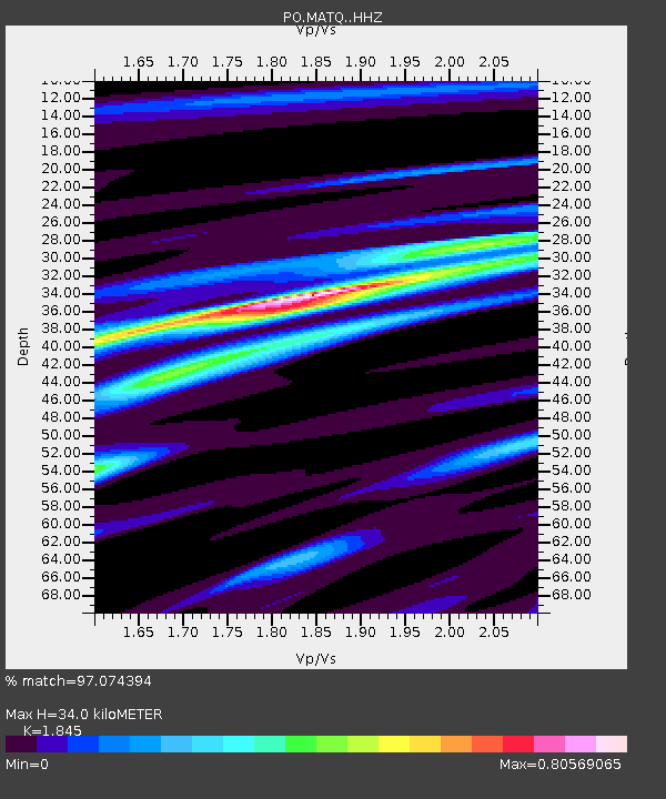
| Estimated Moho Depth: |
34.0 km |
| Estimated Crust Vp/Vs: |
1.85 |
| Assumed Crust Vp: |
6.61 km/s |
| Estimated Crust Vs: |
3.583 km/s |
| Estimated Crust Poisson's Ratio: |
0.29 |
|
| Radial Match: |
97.074394 % |
| Radial Bump: |
251 |
| Transverse Match: |
89.774155 % |
| Transverse Bump: |
400 |
| SOD ConfigId: |
22732711 |
| Insert Time: |
2020-11-02 21:17:40.897 +0000 |
| GWidth: |
2.5 |
| Max Bumps: |
400 |
| Tol: |
0.001 |
|

Signal To Noise
| Channel | StoN | STA | LTA |
| PO:MATQ: :HHZ:20201019T21:02:42.549988Z | 11.258961 | 3.4275638E-6 | 3.0442988E-7 |
| PO:MATQ: :HHN:20201019T21:02:42.549988Z | 5.48938 | 1.047026E-6 | 1.9073666E-7 |
| PO:MATQ: :HHE:20201019T21:02:42.549988Z | 5.852825 | 1.6235398E-6 | 2.7739424E-7 |
| Arrivals |
| Ps | 4.6 SECOND |
| PpPs | 14 SECOND |
| PsPs/PpSs | 18 SECOND |


