You are here: Home > Network List > TM - Thai Seismic Monitoring Network Stations List
> Station MHIT MHIT Phase1 > Earthquake Result Viewer
MHIT MHIT Phase1 - Earthquake Result Viewer
| Earthquake location: |
South Of Alaska |
| Earthquake latitude/longitude: |
54.7/-159.6 |
| Earthquake time(UTC): |
2020/10/19 (293) 20:54:40 GMT |
| Earthquake Depth: |
41 km |
| Earthquake Magnitude: |
7.4 Mi |
| Earthquake Catalog/Contributor: |
NEIC PDE/at |
|
| Network: |
TM Thai Seismic Monitoring Network |
| Station: |
MHIT MHIT Phase1 |
| Lat/Lon: |
19.31 N/97.96 E |
| Elevation: |
270 m |
|
| Distance: |
81.4 deg |
| Az: |
291.131 deg |
| Baz: |
35.014 deg |
| Ray Param: |
0.047554806 |
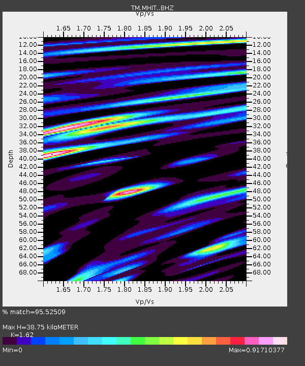
| Estimated Moho Depth: |
38.75 km |
| Estimated Crust Vp/Vs: |
1.62 |
| Assumed Crust Vp: |
6.316 km/s |
| Estimated Crust Vs: |
3.898 km/s |
| Estimated Crust Poisson's Ratio: |
0.19 |
|
| Radial Match: |
95.52509 % |
| Radial Bump: |
400 |
| Transverse Match: |
97.836784 % |
| Transverse Bump: |
307 |
| SOD ConfigId: |
22732711 |
| Insert Time: |
2020-11-02 21:19:32.004 +0000 |
| GWidth: |
2.5 |
| Max Bumps: |
400 |
| Tol: |
0.001 |
|

Signal To Noise
| Channel | StoN | STA | LTA |
| TM:MHIT: :BHZ:20201019T21:06:21.460022Z | 37.13801 | 3.6639672E-6 | 9.8658155E-8 |
| TM:MHIT: :BHN:20201019T21:06:21.460022Z | 15.862761 | 2.8952536E-6 | 1.8251889E-7 |
| TM:MHIT: :BHE:20201019T21:06:21.460022Z | 1.8736621 | 2.4066915E-7 | 1.2844853E-7 |
| Arrivals |
| Ps | 3.9 SECOND |
| PpPs | 16 SECOND |
| PsPs/PpSs | 20 SECOND |


