You are here: Home > Network List > TX - Texas Seismological Network Stations List
> Station EF02 Christine > Earthquake Result Viewer
EF02 Christine - Earthquake Result Viewer
| Earthquake location: |
South Of Alaska |
| Earthquake latitude/longitude: |
54.7/-159.6 |
| Earthquake time(UTC): |
2020/10/19 (293) 20:54:40 GMT |
| Earthquake Depth: |
41 km |
| Earthquake Magnitude: |
7.4 Mi |
| Earthquake Catalog/Contributor: |
NEIC PDE/at |
|
| Network: |
TX Texas Seismological Network |
| Station: |
EF02 Christine |
| Lat/Lon: |
28.78 N/98.53 W |
| Elevation: |
96 m |
|
| Distance: |
50.5 deg |
| Az: |
95.01 deg |
| Baz: |
318.759 deg |
| Ray Param: |
0.0679398 |
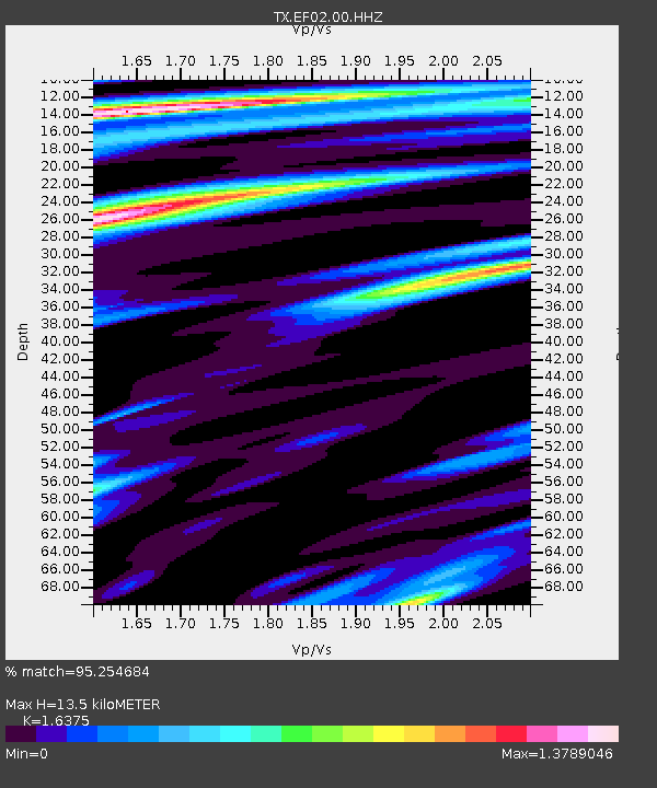
| Estimated Moho Depth: |
13.5 km |
| Estimated Crust Vp/Vs: |
1.64 |
| Assumed Crust Vp: |
6.347 km/s |
| Estimated Crust Vs: |
3.876 km/s |
| Estimated Crust Poisson's Ratio: |
0.20 |
|
| Radial Match: |
95.254684 % |
| Radial Bump: |
400 |
| Transverse Match: |
92.39835 % |
| Transverse Bump: |
400 |
| SOD ConfigId: |
22732711 |
| Insert Time: |
2020-11-02 21:19:52.866 +0000 |
| GWidth: |
2.5 |
| Max Bumps: |
400 |
| Tol: |
0.001 |
|

Signal To Noise
| Channel | StoN | STA | LTA |
| TX:EF02:00:HHZ:20201019T21:03:03.230011Z | 10.350096 | 2.005131E-6 | 1.9373066E-7 |
| TX:EF02:00:HHN:20201019T21:03:03.230011Z | 0.9609341 | 3.3381613E-7 | 3.4738713E-7 |
| TX:EF02:00:HHE:20201019T21:03:03.230011Z | 1.7319876 | 6.728005E-7 | 3.8845573E-7 |
| Arrivals |
| Ps | 1.4 SECOND |
| PpPs | 5.3 SECOND |
| PsPs/PpSs | 6.7 SECOND |


