You are here: Home > Network List > TX - Texas Seismological Network Stations List
> Station FW06 Azle > Earthquake Result Viewer
FW06 Azle - Earthquake Result Viewer
| Earthquake location: |
South Of Alaska |
| Earthquake latitude/longitude: |
54.7/-159.6 |
| Earthquake time(UTC): |
2020/10/19 (293) 20:54:40 GMT |
| Earthquake Depth: |
41 km |
| Earthquake Magnitude: |
7.4 Mi |
| Earthquake Catalog/Contributor: |
NEIC PDE/at |
|
| Network: |
TX Texas Seismological Network |
| Station: |
FW06 Azle |
| Lat/Lon: |
32.97 N/97.56 W |
| Elevation: |
233 m |
|
| Distance: |
48.0 deg |
| Az: |
90.463 deg |
| Baz: |
316.284 deg |
| Ray Param: |
0.069588766 |
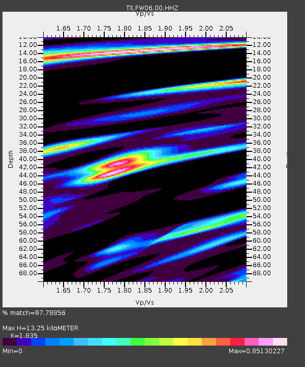
| Estimated Moho Depth: |
13.25 km |
| Estimated Crust Vp/Vs: |
1.84 |
| Assumed Crust Vp: |
6.38 km/s |
| Estimated Crust Vs: |
3.477 km/s |
| Estimated Crust Poisson's Ratio: |
0.29 |
|
| Radial Match: |
97.78856 % |
| Radial Bump: |
225 |
| Transverse Match: |
88.46261 % |
| Transverse Bump: |
400 |
| SOD ConfigId: |
22732711 |
| Insert Time: |
2020-11-02 21:20:02.982 +0000 |
| GWidth: |
2.5 |
| Max Bumps: |
400 |
| Tol: |
0.001 |
|

Signal To Noise
| Channel | StoN | STA | LTA |
| TX:FW06:00:HHZ:20201019T21:02:44.000Z | 10.433116 | 1.7724655E-6 | 1.6988841E-7 |
| TX:FW06:00:HH1:20201019T21:02:44.000Z | 3.962489 | 7.9429424E-7 | 2.0045337E-7 |
| TX:FW06:00:HH2:20201019T21:02:44.000Z | 2.1489413 | 4.7064776E-7 | 2.1901378E-7 |
| Arrivals |
| Ps | 1.8 SECOND |
| PpPs | 5.6 SECOND |
| PsPs/PpSs | 7.4 SECOND |


