You are here: Home > Network List > TX - Texas Seismological Network Stations List
> Station FW15 Z > Earthquake Result Viewer
FW15 Z - Earthquake Result Viewer
| Earthquake location: |
South Of Alaska |
| Earthquake latitude/longitude: |
54.7/-159.6 |
| Earthquake time(UTC): |
2020/10/19 (293) 20:54:40 GMT |
| Earthquake Depth: |
41 km |
| Earthquake Magnitude: |
7.4 Mi |
| Earthquake Catalog/Contributor: |
NEIC PDE/at |
|
| Network: |
TX Texas Seismological Network |
| Station: |
FW15 Z |
| Lat/Lon: |
32.70 N/97.37 W |
| Elevation: |
192 m |
|
| Distance: |
48.3 deg |
| Az: |
90.557 deg |
| Baz: |
316.448 deg |
| Ray Param: |
0.06938831 |
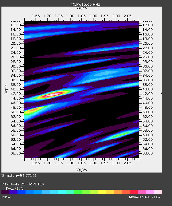
| Estimated Moho Depth: |
42.25 km |
| Estimated Crust Vp/Vs: |
1.72 |
| Assumed Crust Vp: |
6.38 km/s |
| Estimated Crust Vs: |
3.715 km/s |
| Estimated Crust Poisson's Ratio: |
0.24 |
|
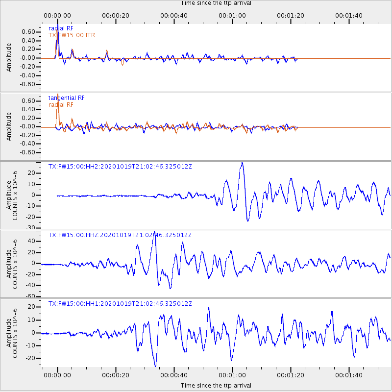
| Radial Match: |
94.77151 % |
| Radial Bump: |
302 |
| Transverse Match: |
89.171196 % |
| Transverse Bump: |
400 |
| SOD ConfigId: |
22732711 |
| Insert Time: |
2020-11-02 21:20:10.803 +0000 |
| GWidth: |
2.5 |
| Max Bumps: |
400 |
| Tol: |
0.001 |
|
Signal To Noise
| Channel | StoN | STA | LTA |
| TX:FW15:00:HHZ:20201019T21:02:46.325012Z | 5.9588656 | 1.7407402E-6 | 2.921261E-7 |
| TX:FW15:00:HH1:20201019T21:02:46.325012Z | 2.5835729 | 5.4709926E-7 | 2.1176072E-7 |
| TX:FW15:00:HH2:20201019T21:02:46.325012Z | 2.9395618 | 6.302886E-7 | 2.1441583E-7 |
| Arrivals |
| Ps | 5.1 SECOND |
| PpPs | 17 SECOND |
| PsPs/PpSs | 22 SECOND |


