You are here: Home > Network List > TX - Texas Seismological Network Stations List
> Station MB04 Seminole > Earthquake Result Viewer
MB04 Seminole - Earthquake Result Viewer
| Earthquake location: |
South Of Alaska |
| Earthquake latitude/longitude: |
54.7/-159.6 |
| Earthquake time(UTC): |
2020/10/19 (293) 20:54:40 GMT |
| Earthquake Depth: |
41 km |
| Earthquake Magnitude: |
7.4 Mi |
| Earthquake Catalog/Contributor: |
NEIC PDE/at |
|
| Network: |
TX Texas Seismological Network |
| Station: |
MB04 Seminole |
| Lat/Lon: |
32.63 N/102.49 W |
| Elevation: |
956 m |
|
| Distance: |
45.3 deg |
| Az: |
94.932 deg |
| Baz: |
316.694 deg |
| Ray Param: |
0.07124858 |
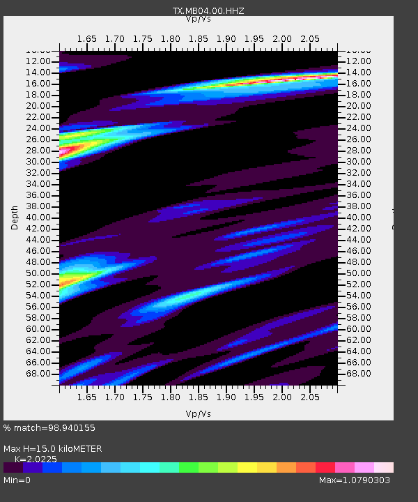
| Estimated Moho Depth: |
15.0 km |
| Estimated Crust Vp/Vs: |
2.02 |
| Assumed Crust Vp: |
6.129 km/s |
| Estimated Crust Vs: |
3.03 km/s |
| Estimated Crust Poisson's Ratio: |
0.34 |
|
| Radial Match: |
98.940155 % |
| Radial Bump: |
245 |
| Transverse Match: |
93.78843 % |
| Transverse Bump: |
347 |
| SOD ConfigId: |
22732711 |
| Insert Time: |
2020-11-02 21:20:21.386 +0000 |
| GWidth: |
2.5 |
| Max Bumps: |
400 |
| Tol: |
0.001 |
|

Signal To Noise
| Channel | StoN | STA | LTA |
| TX:MB04:00:HHZ:20201019T21:02:23.609985Z | 20.996881 | 1.8626118E-6 | 8.870897E-8 |
| TX:MB04:00:HH1:20201019T21:02:23.609985Z | 1.7400762 | 4.6041822E-7 | 2.645966E-7 |
| TX:MB04:00:HH2:20201019T21:02:23.609985Z | 3.2425396 | 4.4057487E-7 | 1.3587339E-7 |
| Arrivals |
| Ps | 2.6 SECOND |
| PpPs | 7.0 SECOND |
| PsPs/PpSs | 9.7 SECOND |


