You are here: Home > Network List > TX - Texas Seismological Network Stations List
> Station PB04 Verhalen > Earthquake Result Viewer
PB04 Verhalen - Earthquake Result Viewer
| Earthquake location: |
South Of Alaska |
| Earthquake latitude/longitude: |
54.7/-159.6 |
| Earthquake time(UTC): |
2020/10/19 (293) 20:54:40 GMT |
| Earthquake Depth: |
41 km |
| Earthquake Magnitude: |
7.4 Mi |
| Earthquake Catalog/Contributor: |
NEIC PDE/at |
|
| Network: |
TX Texas Seismological Network |
| Station: |
PB04 Verhalen |
| Lat/Lon: |
31.19 N/103.27 W |
| Elevation: |
812 m |
|
| Distance: |
45.9 deg |
| Az: |
96.977 deg |
| Baz: |
317.713 deg |
| Ray Param: |
0.07087696 |
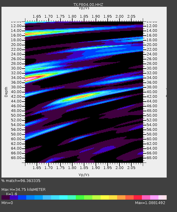
| Estimated Moho Depth: |
34.75 km |
| Estimated Crust Vp/Vs: |
1.60 |
| Assumed Crust Vp: |
6.121 km/s |
| Estimated Crust Vs: |
3.825 km/s |
| Estimated Crust Poisson's Ratio: |
0.18 |
|
| Radial Match: |
96.363335 % |
| Radial Bump: |
400 |
| Transverse Match: |
86.551704 % |
| Transverse Bump: |
400 |
| SOD ConfigId: |
22732711 |
| Insert Time: |
2020-11-02 21:20:35.614 +0000 |
| GWidth: |
2.5 |
| Max Bumps: |
400 |
| Tol: |
0.001 |
|

Signal To Noise
| Channel | StoN | STA | LTA |
| TX:PB04:00:HHZ:20201019T21:02:28.350006Z | 3.814019 | 1.0665213E-6 | 2.796319E-7 |
| TX:PB04:00:HH1:20201019T21:02:28.350006Z | 2.502798 | 3.8680506E-7 | 1.5454904E-7 |
| TX:PB04:00:HH2:20201019T21:02:28.350006Z | 1.3881574 | 2.741843E-7 | 1.9751673E-7 |
| Arrivals |
| Ps | 3.6 SECOND |
| PpPs | 14 SECOND |
| PsPs/PpSs | 17 SECOND |


