You are here: Home > Network List > TX - Texas Seismological Network Stations List
> Station PB05 Z > Earthquake Result Viewer
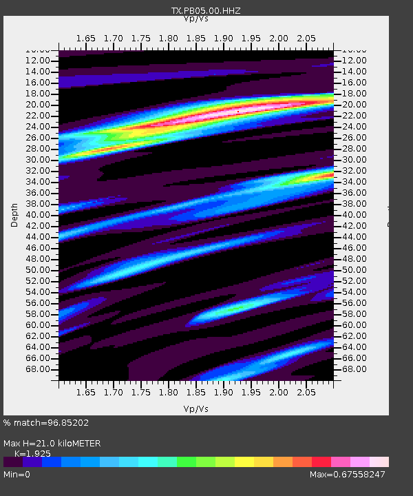
PB05 Z - Earthquake Result Viewer
| Earthquake location: |
South Of Alaska |
| Earthquake latitude/longitude: |
54.7/-159.6 |
| Earthquake time(UTC): |
2020/10/19 (293) 20:54:40 GMT |
| Earthquake Depth: |
41 km |
| Earthquake Magnitude: |
7.4 Mi |
| Earthquake Catalog/Contributor: |
NEIC PDE/at |
|
| Network: |
TX Texas Seismological Network |
| Station: |
PB05 Z |
| Lat/Lon: |
30.92 N/103.32 W |
| Elevation: |
957 m |
|
| Distance: |
46.1 deg |
| Az: |
97.275 deg |
| Baz: |
317.891 deg |
| Ray Param: |
0.07077267 |
| Estimated Moho Depth: |
21.0 km |
| Estimated Crust Vp/Vs: |
1.92 |
| Assumed Crust Vp: |
6.121 km/s |
| Estimated Crust Vs: |
3.179 km/s |
| Estimated Crust Poisson's Ratio: |
0.32 |
|
| Radial Match: |
96.85202 % |
| Radial Bump: |
246 |
| Transverse Match: |
91.430534 % |
| Transverse Bump: |
400 |
| SOD ConfigId: |
22732711 |
| Insert Time: |
2020-11-02 21:20:36.485 +0000 |
| GWidth: |
2.5 |
| Max Bumps: |
400 |
| Tol: |
0.001 |
|

Signal To Noise
| Channel | StoN | STA | LTA |
| TX:PB05:00:HHZ:20201019T21:02:29.649994Z | 2.500187 | 1.0393882E-6 | 4.1572417E-7 |
| TX:PB05:00:HH1:20201019T21:02:29.649994Z | 2.5526326 | 3.7348605E-7 | 1.4631406E-7 |
| TX:PB05:00:HH2:20201019T21:02:29.649994Z | 2.6345398 | 2.4719017E-7 | 9.38267E-8 |
| Arrivals |
| Ps | 3.3 SECOND |
| PpPs | 9.5 SECOND |
| PsPs/PpSs | 13 SECOND |


