You are here: Home > Network List > TX - Texas Seismological Network Stations List
> Station PB10 Southeast of Toyah > Earthquake Result Viewer
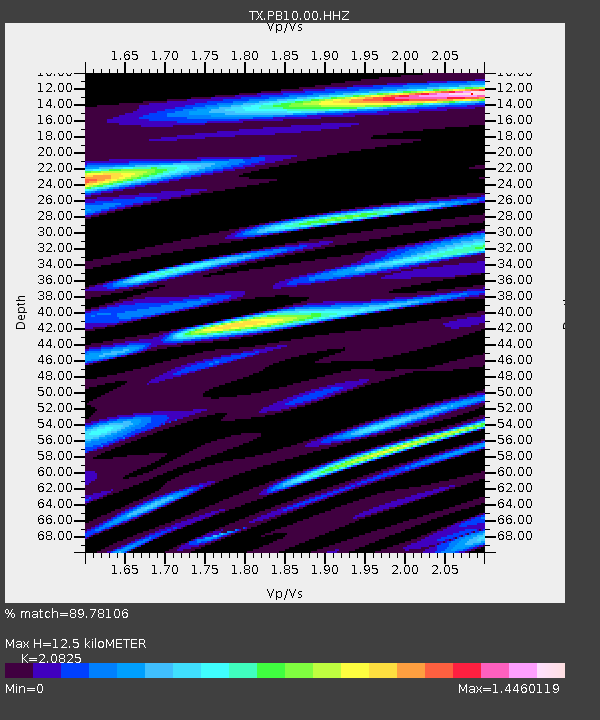
PB10 Southeast of Toyah - Earthquake Result Viewer
| Earthquake location: |
South Of Alaska |
| Earthquake latitude/longitude: |
54.7/-159.6 |
| Earthquake time(UTC): |
2020/10/19 (293) 20:54:40 GMT |
| Earthquake Depth: |
41 km |
| Earthquake Magnitude: |
7.4 Mi |
| Earthquake Catalog/Contributor: |
NEIC PDE/at |
|
| Network: |
TX Texas Seismological Network |
| Station: |
PB10 Southeast of Toyah |
| Lat/Lon: |
31.28 N/103.75 W |
| Elevation: |
858 m |
|
| Distance: |
45.6 deg |
| Az: |
97.316 deg |
| Baz: |
317.699 deg |
| Ray Param: |
0.07107903 |
| Estimated Moho Depth: |
12.5 km |
| Estimated Crust Vp/Vs: |
2.08 |
| Assumed Crust Vp: |
6.121 km/s |
| Estimated Crust Vs: |
2.939 km/s |
| Estimated Crust Poisson's Ratio: |
0.35 |
|
| Radial Match: |
89.78106 % |
| Radial Bump: |
400 |
| Transverse Match: |
75.258156 % |
| Transverse Bump: |
400 |
| SOD ConfigId: |
22732711 |
| Insert Time: |
2020-11-02 21:20:43.140 +0000 |
| GWidth: |
2.5 |
| Max Bumps: |
400 |
| Tol: |
0.001 |
|

Signal To Noise
| Channel | StoN | STA | LTA |
| TX:PB10:00:HHZ:20201019T21:02:25.579987Z | 4.318707 | 9.217427E-7 | 2.1343025E-7 |
| TX:PB10:00:HH1:20201019T21:02:25.579987Z | 1.4948076 | 3.5561095E-7 | 2.3789747E-7 |
| TX:PB10:00:HH2:20201019T21:02:25.579987Z | 1.5659751 | 4.3536923E-7 | 2.7801798E-7 |
| Arrivals |
| Ps | 2.3 SECOND |
| PpPs | 6.0 SECOND |
| PsPs/PpSs | 8.3 SECOND |


