You are here: Home > Network List > TX - Texas Seismological Network Stations List
> Station PB14 Weatherby Road > Earthquake Result Viewer
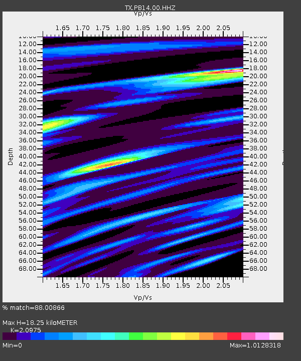
PB14 Weatherby Road - Earthquake Result Viewer
| Earthquake location: |
South Of Alaska |
| Earthquake latitude/longitude: |
54.7/-159.6 |
| Earthquake time(UTC): |
2020/10/19 (293) 20:54:40 GMT |
| Earthquake Depth: |
41 km |
| Earthquake Magnitude: |
7.4 Mi |
| Earthquake Catalog/Contributor: |
NEIC PDE/at |
|
| Network: |
TX Texas Seismological Network |
| Station: |
PB14 Weatherby Road |
| Lat/Lon: |
31.13 N/103.15 W |
| Elevation: |
807 m |
|
| Distance: |
46.1 deg |
| Az: |
96.927 deg |
| Baz: |
317.739 deg |
| Ray Param: |
0.07080745 |
| Estimated Moho Depth: |
18.25 km |
| Estimated Crust Vp/Vs: |
2.10 |
| Assumed Crust Vp: |
6.121 km/s |
| Estimated Crust Vs: |
2.918 km/s |
| Estimated Crust Poisson's Ratio: |
0.35 |
|
| Radial Match: |
88.00866 % |
| Radial Bump: |
400 |
| Transverse Match: |
68.35571 % |
| Transverse Bump: |
400 |
| SOD ConfigId: |
22732711 |
| Insert Time: |
2020-11-02 21:20:46.767 +0000 |
| GWidth: |
2.5 |
| Max Bumps: |
400 |
| Tol: |
0.001 |
|

Signal To Noise
| Channel | StoN | STA | LTA |
| TX:PB14:00:HHZ:20201019T21:02:29.214996Z | 5.5077662 | 0.0023695675 | 4.3022295E-4 |
| TX:PB14:00:HHN:20201019T21:02:29.214996Z | 0.25267202 | 0.0013253753 | 0.0052454374 |
| TX:PB14:00:HHE:20201019T21:02:29.214996Z | 1.8685191 | 0.0010155706 | 5.435163E-4 |
| Arrivals |
| Ps | 3.4 SECOND |
| PpPs | 8.8 SECOND |
| PsPs/PpSs | 12 SECOND |


