You are here: Home > Network List > TX - Texas Seismological Network Stations List
> Station SN03 Snyder 3 > Earthquake Result Viewer
SN03 Snyder 3 - Earthquake Result Viewer
| Earthquake location: |
South Of Alaska |
| Earthquake latitude/longitude: |
54.7/-159.6 |
| Earthquake time(UTC): |
2020/10/19 (293) 20:54:40 GMT |
| Earthquake Depth: |
41 km |
| Earthquake Magnitude: |
7.4 Mi |
| Earthquake Catalog/Contributor: |
NEIC PDE/at |
|
| Network: |
TX Texas Seismological Network |
| Station: |
SN03 Snyder 3 |
| Lat/Lon: |
32.92 N/100.94 W |
| Elevation: |
744 m |
|
| Distance: |
46.0 deg |
| Az: |
93.324 deg |
| Baz: |
316.404 deg |
| Ray Param: |
0.07082752 |
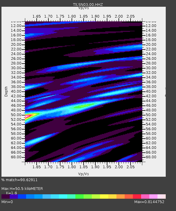
| Estimated Moho Depth: |
50.5 km |
| Estimated Crust Vp/Vs: |
1.60 |
| Assumed Crust Vp: |
6.426 km/s |
| Estimated Crust Vs: |
4.016 km/s |
| Estimated Crust Poisson's Ratio: |
0.18 |
|
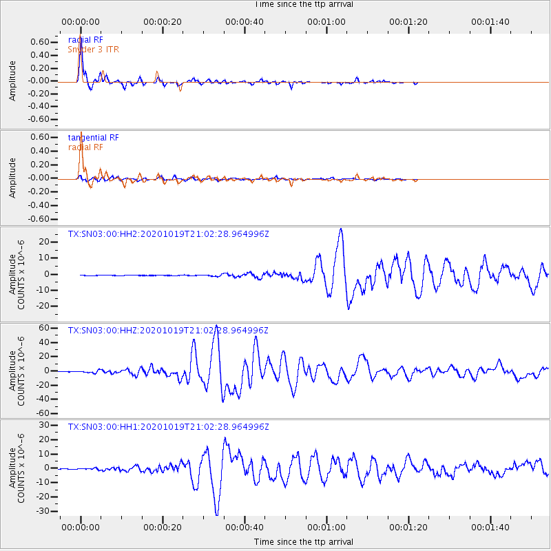
| Radial Match: |
98.62911 % |
| Radial Bump: |
277 |
| Transverse Match: |
90.05864 % |
| Transverse Bump: |
400 |
| SOD ConfigId: |
22732711 |
| Insert Time: |
2020-11-02 21:21:06.443 +0000 |
| GWidth: |
2.5 |
| Max Bumps: |
400 |
| Tol: |
0.001 |
|
Signal To Noise
| Channel | StoN | STA | LTA |
| TX:SN03:00:HHZ:20201019T21:02:28.964996Z | 11.826465 | 1.5783321E-6 | 1.3345765E-7 |
| TX:SN03:00:HH1:20201019T21:02:28.964996Z | 5.4599104 | 4.8103715E-7 | 8.810349E-8 |
| TX:SN03:00:HH2:20201019T21:02:28.964996Z | 3.4901493 | 5.184762E-7 | 1.4855416E-7 |
| Arrivals |
| Ps | 5.1 SECOND |
| PpPs | 19 SECOND |
| PsPs/PpSs | 24 SECOND |


