You are here: Home > Network List > TX - Texas Seismological Network Stations List
> Station SN07 Snyder 07 > Earthquake Result Viewer
SN07 Snyder 07 - Earthquake Result Viewer
| Earthquake location: |
South Of Alaska |
| Earthquake latitude/longitude: |
54.7/-159.6 |
| Earthquake time(UTC): |
2020/10/19 (293) 20:54:40 GMT |
| Earthquake Depth: |
41 km |
| Earthquake Magnitude: |
7.4 Mi |
| Earthquake Catalog/Contributor: |
NEIC PDE/at |
|
| Network: |
TX Texas Seismological Network |
| Station: |
SN07 Snyder 07 |
| Lat/Lon: |
33.09 N/100.89 W |
| Elevation: |
620 m |
|
| Distance: |
45.9 deg |
| Az: |
93.122 deg |
| Baz: |
316.291 deg |
| Ray Param: |
0.07088474 |
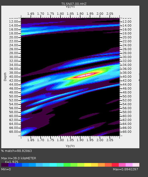
| Estimated Moho Depth: |
39.0 km |
| Estimated Crust Vp/Vs: |
1.92 |
| Assumed Crust Vp: |
6.426 km/s |
| Estimated Crust Vs: |
3.338 km/s |
| Estimated Crust Poisson's Ratio: |
0.32 |
|
| Radial Match: |
98.92863 % |
| Radial Bump: |
220 |
| Transverse Match: |
93.91337 % |
| Transverse Bump: |
367 |
| SOD ConfigId: |
22732711 |
| Insert Time: |
2020-11-02 21:21:08.522 +0000 |
| GWidth: |
2.5 |
| Max Bumps: |
400 |
| Tol: |
0.001 |
|

Signal To Noise
| Channel | StoN | STA | LTA |
| TX:SN07:00:HHZ:20201019T21:02:28.244995Z | 15.700011 | 2.0720254E-6 | 1.3197604E-7 |
| TX:SN07:00:HH1:20201019T21:02:28.244995Z | 5.7829113 | 5.708497E-7 | 9.87132E-8 |
| TX:SN07:00:HH2:20201019T21:02:28.244995Z | 5.0926023 | 6.5712396E-7 | 1.29035E-7 |
| Arrivals |
| Ps | 5.9 SECOND |
| PpPs | 17 SECOND |
| PsPs/PpSs | 23 SECOND |


