You are here: Home > Network List > TX - Texas Seismological Network Stations List
> Station SN10 Rotan > Earthquake Result Viewer
SN10 Rotan - Earthquake Result Viewer
| Earthquake location: |
South Of Alaska |
| Earthquake latitude/longitude: |
54.7/-159.6 |
| Earthquake time(UTC): |
2020/10/19 (293) 20:54:40 GMT |
| Earthquake Depth: |
41 km |
| Earthquake Magnitude: |
7.4 Mi |
| Earthquake Catalog/Contributor: |
NEIC PDE/at |
|
| Network: |
TX Texas Seismological Network |
| Station: |
SN10 Rotan |
| Lat/Lon: |
33.05 N/100.72 W |
| Elevation: |
658 m |
|
| Distance: |
46.1 deg |
| Az: |
93.021 deg |
| Baz: |
316.311 deg |
| Ray Param: |
0.07080479 |
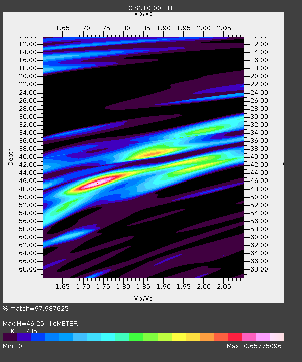
| Estimated Moho Depth: |
46.25 km |
| Estimated Crust Vp/Vs: |
1.74 |
| Assumed Crust Vp: |
6.426 km/s |
| Estimated Crust Vs: |
3.704 km/s |
| Estimated Crust Poisson's Ratio: |
0.25 |
|
| Radial Match: |
97.987625 % |
| Radial Bump: |
288 |
| Transverse Match: |
92.99705 % |
| Transverse Bump: |
400 |
| SOD ConfigId: |
22732711 |
| Insert Time: |
2020-11-02 21:21:11.875 +0000 |
| GWidth: |
2.5 |
| Max Bumps: |
400 |
| Tol: |
0.001 |
|

Signal To Noise
| Channel | StoN | STA | LTA |
| TX:SN10:00:HHZ:20201019T21:02:29.250Z | 10.059633 | 1.3069293E-6 | 1.2991819E-7 |
| TX:SN10:00:HH1:20201019T21:02:29.250Z | 2.7866292 | 3.786491E-7 | 1.358807E-7 |
| TX:SN10:00:HH2:20201019T21:02:29.250Z | 1.6311636 | 3.7297994E-7 | 2.2865883E-7 |
| Arrivals |
| Ps | 5.6 SECOND |
| PpPs | 18 SECOND |
| PsPs/PpSs | 24 SECOND |


