You are here: Home > Network List > US - United States National Seismic Network Stations List
> Station BINY Binghamton, New York, USA > Earthquake Result Viewer
BINY Binghamton, New York, USA - Earthquake Result Viewer
| Earthquake location: |
South Of Alaska |
| Earthquake latitude/longitude: |
54.7/-159.6 |
| Earthquake time(UTC): |
2020/10/19 (293) 20:54:40 GMT |
| Earthquake Depth: |
41 km |
| Earthquake Magnitude: |
7.4 Mi |
| Earthquake Catalog/Contributor: |
NEIC PDE/at |
|
| Network: |
US United States National Seismic Network |
| Station: |
BINY Binghamton, New York, USA |
| Lat/Lon: |
42.20 N/75.99 W |
| Elevation: |
498 m |
|
| Distance: |
53.7 deg |
| Az: |
66.467 deg |
| Baz: |
314.209 deg |
| Ray Param: |
0.0658719 |
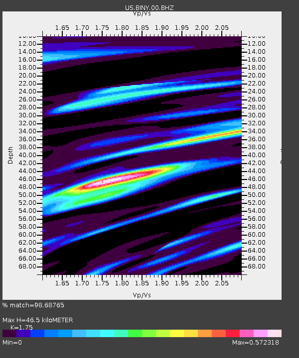
| Estimated Moho Depth: |
46.5 km |
| Estimated Crust Vp/Vs: |
1.75 |
| Assumed Crust Vp: |
6.419 km/s |
| Estimated Crust Vs: |
3.668 km/s |
| Estimated Crust Poisson's Ratio: |
0.26 |
|
| Radial Match: |
98.68765 % |
| Radial Bump: |
305 |
| Transverse Match: |
95.12685 % |
| Transverse Bump: |
400 |
| SOD ConfigId: |
22732711 |
| Insert Time: |
2020-11-02 21:21:30.598 +0000 |
| GWidth: |
2.5 |
| Max Bumps: |
400 |
| Tol: |
0.001 |
|
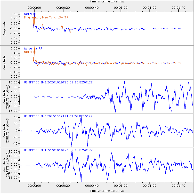
Signal To Noise
| Channel | StoN | STA | LTA |
| US:BINY:00:BHZ:20201019T21:03:26.825012Z | 20.543633 | 3.5630942E-6 | 1.7344033E-7 |
| US:BINY:00:BH1:20201019T21:03:26.825012Z | 5.7596292 | 1.0908426E-6 | 1.893946E-7 |
| US:BINY:00:BH2:20201019T21:03:26.825012Z | 4.189697 | 1.0116017E-6 | 2.4144987E-7 |
| Arrivals |
| Ps | 5.7 SECOND |
| PpPs | 19 SECOND |
| PsPs/PpSs | 25 SECOND |


