You are here: Home > Network List > US - United States National Seismic Network Stations List
> Station BRAL Brewton, Alabama, USA > Earthquake Result Viewer
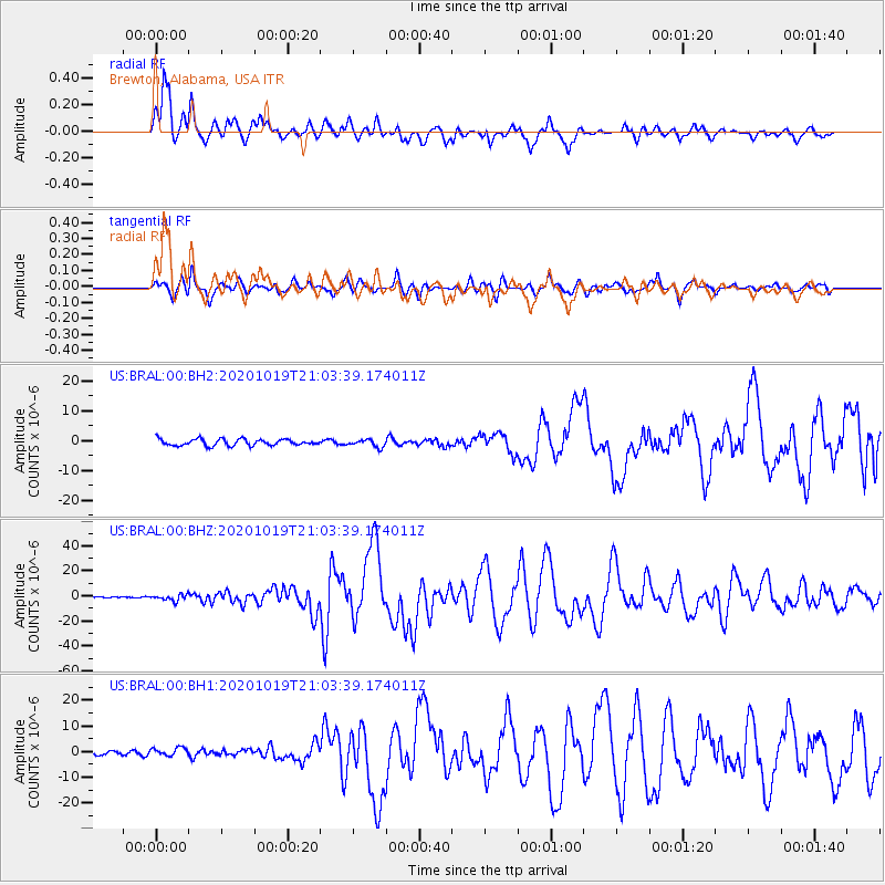
BRAL Brewton, Alabama, USA - Earthquake Result Viewer
*The percent match for this event was below the threshold and hence no stack was calculated.
| Earthquake location: |
South Of Alaska |
| Earthquake latitude/longitude: |
54.7/-159.6 |
| Earthquake time(UTC): |
2020/10/19 (293) 20:54:40 GMT |
| Earthquake Depth: |
41 km |
| Earthquake Magnitude: |
7.4 Mi |
| Earthquake Catalog/Contributor: |
NEIC PDE/at |
|
| Network: |
US United States National Seismic Network |
| Station: |
BRAL Brewton, Alabama, USA |
| Lat/Lon: |
31.17 N/87.05 W |
| Elevation: |
61 m |
|
| Distance: |
55.4 deg |
| Az: |
83.715 deg |
| Baz: |
317.65 deg |
| Ray Param: |
$rayparam |
*The percent match for this event was below the threshold and hence was not used in the summary stack. |
|
| Radial Match: |
96.32675 % |
| Radial Bump: |
400 |
| Transverse Match: |
90.12288 % |
| Transverse Bump: |
400 |
| SOD ConfigId: |
22732711 |
| Insert Time: |
2020-11-02 21:21:36.211 +0000 |
| GWidth: |
2.5 |
| Max Bumps: |
400 |
| Tol: |
0.001 |
|
Signal To Noise
| Channel | StoN | STA | LTA |
| US:BRAL:00:BHZ:20201019T21:03:39.174011Z | 4.186099 | 2.513079E-6 | 6.003391E-7 |
| US:BRAL:00:BH1:20201019T21:03:39.174011Z | 2.127926 | 1.5593464E-6 | 7.32801E-7 |
| US:BRAL:00:BH2:20201019T21:03:39.174011Z | 1.1595517 | 1.2382062E-6 | 1.0678317E-6 |
| Arrivals |
| Ps | |
| PpPs | |
| PsPs/PpSs | |


