You are here: Home > Network List > US - United States National Seismic Network Stations List
> Station GLMI Grayling, Michigan, USA > Earthquake Result Viewer
GLMI Grayling, Michigan, USA - Earthquake Result Viewer
| Earthquake location: |
South Of Alaska |
| Earthquake latitude/longitude: |
54.7/-159.6 |
| Earthquake time(UTC): |
2020/10/19 (293) 20:54:40 GMT |
| Earthquake Depth: |
41 km |
| Earthquake Magnitude: |
7.4 Mi |
| Earthquake Catalog/Contributor: |
NEIC PDE/at |
|
| Network: |
US United States National Seismic Network |
| Station: |
GLMI Grayling, Michigan, USA |
| Lat/Lon: |
44.82 N/84.62 W |
| Elevation: |
387 m |
|
| Distance: |
47.2 deg |
| Az: |
69.416 deg |
| Baz: |
310.161 deg |
| Ray Param: |
0.070025645 |
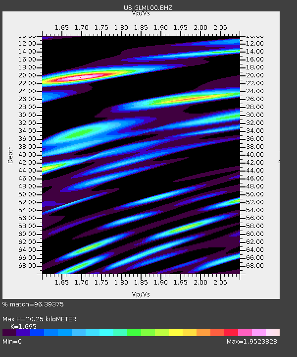
| Estimated Moho Depth: |
20.25 km |
| Estimated Crust Vp/Vs: |
1.70 |
| Assumed Crust Vp: |
6.483 km/s |
| Estimated Crust Vs: |
3.825 km/s |
| Estimated Crust Poisson's Ratio: |
0.23 |
|
| Radial Match: |
96.39375 % |
| Radial Bump: |
400 |
| Transverse Match: |
93.371826 % |
| Transverse Bump: |
400 |
| SOD ConfigId: |
22732711 |
| Insert Time: |
2020-11-02 21:21:51.200 +0000 |
| GWidth: |
2.5 |
| Max Bumps: |
400 |
| Tol: |
0.001 |
|

Signal To Noise
| Channel | StoN | STA | LTA |
| US:GLMI:00:BHZ:20201019T21:02:38.500Z | 15.620944 | 4.3633145E-6 | 2.793246E-7 |
| US:GLMI:00:BH1:20201019T21:02:38.500Z | 8.103312 | 3.0867204E-6 | 3.8092085E-7 |
| US:GLMI:00:BH2:20201019T21:02:38.500Z | 7.9983153 | 3.2340877E-6 | 4.043461E-7 |
| Arrivals |
| Ps | 2.3 SECOND |
| PpPs | 7.9 SECOND |
| PsPs/PpSs | 10 SECOND |


