You are here: Home > Network List > US - United States National Seismic Network Stations List
> Station KSU1 Kansas State University--Konza Prairie, Kansas, USA > Earthquake Result Viewer
KSU1 Kansas State University--Konza Prairie, Kansas, USA - Earthquake Result Viewer
| Earthquake location: |
South Of Alaska |
| Earthquake latitude/longitude: |
54.7/-159.6 |
| Earthquake time(UTC): |
2020/10/19 (293) 20:54:40 GMT |
| Earthquake Depth: |
41 km |
| Earthquake Magnitude: |
7.4 Mi |
| Earthquake Catalog/Contributor: |
NEIC PDE/at |
|
| Network: |
US United States National Seismic Network |
| Station: |
KSU1 Kansas State University--Konza Prairie, Kansas, USA |
| Lat/Lon: |
39.10 N/96.61 W |
| Elevation: |
347 m |
|
| Distance: |
44.2 deg |
| Az: |
83.632 deg |
| Baz: |
312.098 deg |
| Ray Param: |
0.071965136 |
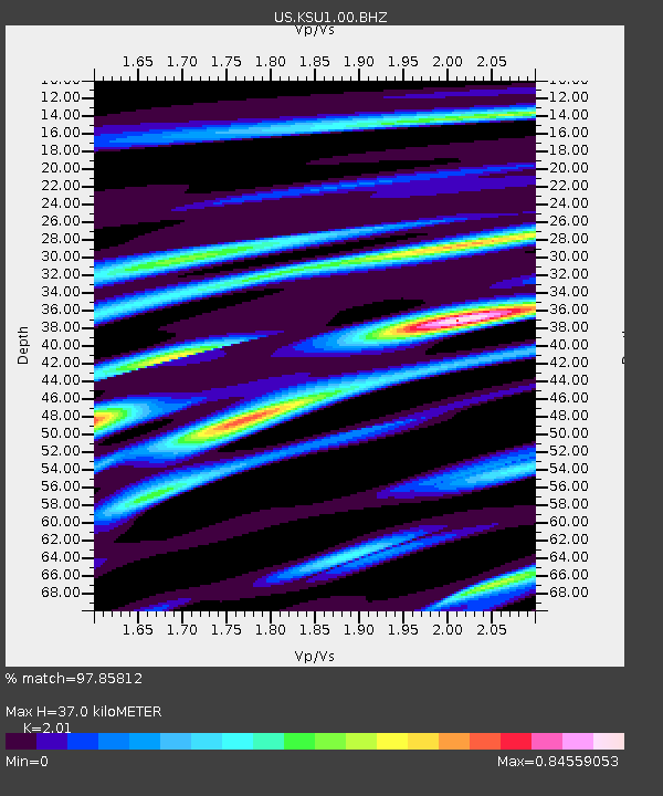
| Estimated Moho Depth: |
37.0 km |
| Estimated Crust Vp/Vs: |
2.01 |
| Assumed Crust Vp: |
6.483 km/s |
| Estimated Crust Vs: |
3.225 km/s |
| Estimated Crust Poisson's Ratio: |
0.34 |
|
| Radial Match: |
97.85812 % |
| Radial Bump: |
400 |
| Transverse Match: |
86.981636 % |
| Transverse Bump: |
400 |
| SOD ConfigId: |
22732711 |
| Insert Time: |
2020-11-02 21:22:00.792 +0000 |
| GWidth: |
2.5 |
| Max Bumps: |
400 |
| Tol: |
0.001 |
|
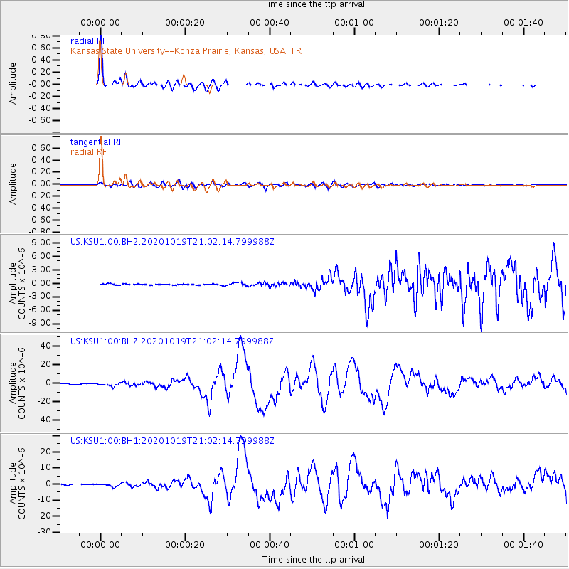
Signal To Noise
| Channel | StoN | STA | LTA |
| US:KSU1:00:BHZ:20201019T21:02:14.799988Z | 9.064864 | 1.6974852E-6 | 1.8725987E-7 |
| US:KSU1:00:BH1:20201019T21:02:14.799988Z | 4.6417007 | 8.9642674E-7 | 1.9312462E-7 |
| US:KSU1:00:BH2:20201019T21:02:14.799988Z | 2.6064222 | 3.2753744E-7 | 1.2566554E-7 |
| Arrivals |
| Ps | 6.1 SECOND |
| PpPs | 16 SECOND |
| PsPs/PpSs | 22 SECOND |


