You are here: Home > Network List > US - United States National Seismic Network Stations List
> Station KVTX Kingsville, Texas, USA > Earthquake Result Viewer
KVTX Kingsville, Texas, USA - Earthquake Result Viewer
| Earthquake location: |
South Of Alaska |
| Earthquake latitude/longitude: |
54.7/-159.6 |
| Earthquake time(UTC): |
2020/10/19 (293) 20:54:40 GMT |
| Earthquake Depth: |
41 km |
| Earthquake Magnitude: |
7.4 Mi |
| Earthquake Catalog/Contributor: |
NEIC PDE/at |
|
| Network: |
US United States National Seismic Network |
| Station: |
KVTX Kingsville, Texas, USA |
| Lat/Lon: |
27.55 N/97.89 W |
| Elevation: |
15 m |
|
| Distance: |
51.8 deg |
| Az: |
95.495 deg |
| Baz: |
319.362 deg |
| Ray Param: |
0.06710904 |
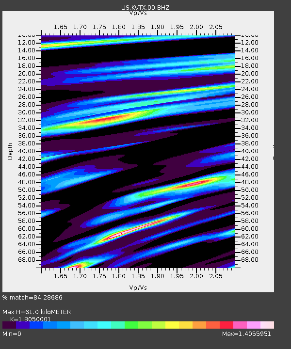
| Estimated Moho Depth: |
61.0 km |
| Estimated Crust Vp/Vs: |
1.81 |
| Assumed Crust Vp: |
5.517 km/s |
| Estimated Crust Vs: |
3.056 km/s |
| Estimated Crust Poisson's Ratio: |
0.28 |
|
| Radial Match: |
84.28686 % |
| Radial Bump: |
400 |
| Transverse Match: |
79.959305 % |
| Transverse Bump: |
400 |
| SOD ConfigId: |
22732711 |
| Insert Time: |
2020-11-02 21:22:02.969 +0000 |
| GWidth: |
2.5 |
| Max Bumps: |
400 |
| Tol: |
0.001 |
|

Signal To Noise
| Channel | StoN | STA | LTA |
| US:KVTX:00:BHZ:20201019T21:03:12.924011Z | 3.2641222 | 1.2025184E-6 | 3.6840487E-7 |
| US:KVTX:00:BH1:20201019T21:03:12.924011Z | 1.2729319 | 5.989222E-7 | 4.705061E-7 |
| US:KVTX:00:BH2:20201019T21:03:12.924011Z | 1.6552373 | 7.782633E-7 | 4.701823E-7 |
| Arrivals |
| Ps | 9.3 SECOND |
| PpPs | 30 SECOND |
| PsPs/PpSs | 39 SECOND |


