You are here: Home > Network List > US - United States National Seismic Network Stations List
> Station MNTX Cornudas Mountains, Texas, USA > Earthquake Result Viewer
MNTX Cornudas Mountains, Texas, USA - Earthquake Result Viewer

| Earthquake location: |
South Of Alaska |
| Earthquake latitude/longitude: |
54.7/-159.6 |
| Earthquake time(UTC): |
2020/10/19 (293) 20:54:40 GMT |
| Earthquake Depth: |
41 km |
| Earthquake Magnitude: |
7.4 Mi |
| Earthquake Catalog/Contributor: |
NEIC PDE/at |
|
| Network: |
US United States National Seismic Network |
| Station: |
MNTX Cornudas Mountains, Texas, USA |
| Lat/Lon: |
31.70 N/105.38 W |
| Elevation: |
404 m |
|
| Distance: |
44.3 deg |
| Az: |
98.375 deg |
| Baz: |
317.603 deg |
| Ray Param: |
0.07189259 |
| Estimated Moho Depth: |
35.75 km |
| Estimated Crust Vp/Vs: |
2.09 |
| Assumed Crust Vp: |
6.361 km/s |
| Estimated Crust Vs: |
3.051 km/s |
| Estimated Crust Poisson's Ratio: |
0.35 |
|
| Radial Match: |
99.19424 % |
| Radial Bump: |
142 |
| Transverse Match: |
95.06856 % |
| Transverse Bump: |
400 |
| SOD ConfigId: |
22732711 |
| Insert Time: |
2020-11-02 21:22:11.635 +0000 |
| GWidth: |
2.5 |
| Max Bumps: |
400 |
| Tol: |
0.001 |
|
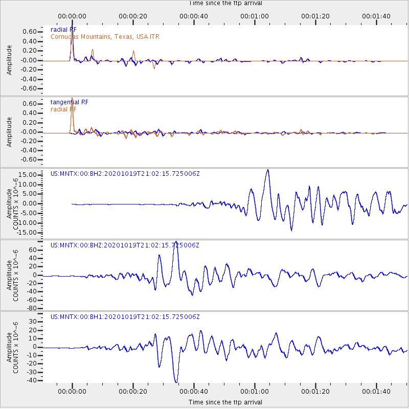
Signal To Noise
| Channel | StoN | STA | LTA |
| US:MNTX:00:BHZ:20201019T21:02:15.725006Z | 8.839323 | 1.2559321E-6 | 1.4208464E-7 |
| US:MNTX:00:BH1:20201019T21:02:15.725006Z | 5.9701357 | 6.121862E-7 | 1.02541435E-7 |
| US:MNTX:00:BH2:20201019T21:02:15.725006Z | 3.0222607 | 2.4242274E-7 | 8.0212395E-8 |
| Arrivals |
| Ps | 6.4 SECOND |
| PpPs | 16 SECOND |
| PsPs/PpSs | 23 SECOND |


