You are here: Home > Network List > UU - University of Utah Regional Network Stations List
> Station KNB Kanab, UT, USA > Earthquake Result Viewer
KNB Kanab, UT, USA - Earthquake Result Viewer
| Earthquake location: |
South Of Alaska |
| Earthquake latitude/longitude: |
54.7/-159.6 |
| Earthquake time(UTC): |
2020/10/19 (293) 20:54:40 GMT |
| Earthquake Depth: |
41 km |
| Earthquake Magnitude: |
7.4 Mi |
| Earthquake Catalog/Contributor: |
NEIC PDE/at |
|
| Network: |
UU University of Utah Regional Network |
| Station: |
KNB Kanab, UT, USA |
| Lat/Lon: |
37.02 N/112.82 W |
| Elevation: |
1715 m |
|
| Distance: |
36.3 deg |
| Az: |
99.52 deg |
| Baz: |
314.29 deg |
| Ray Param: |
0.076717064 |
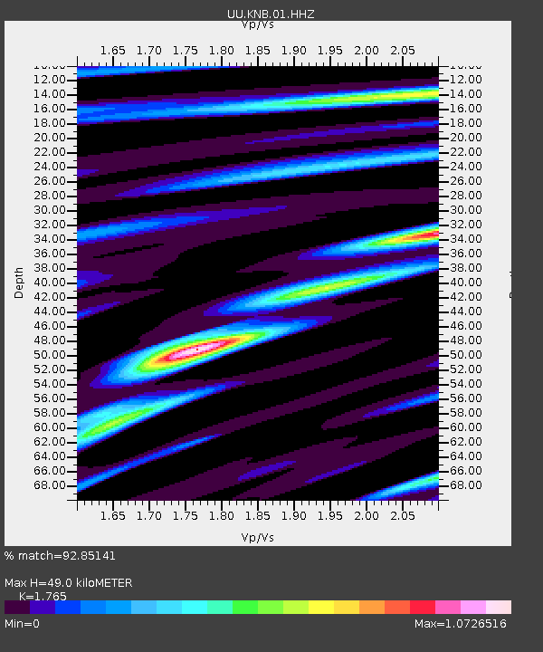
| Estimated Moho Depth: |
49.0 km |
| Estimated Crust Vp/Vs: |
1.76 |
| Assumed Crust Vp: |
6.194 km/s |
| Estimated Crust Vs: |
3.509 km/s |
| Estimated Crust Poisson's Ratio: |
0.26 |
|
| Radial Match: |
92.85141 % |
| Radial Bump: |
301 |
| Transverse Match: |
81.887535 % |
| Transverse Bump: |
387 |
| SOD ConfigId: |
22732711 |
| Insert Time: |
2020-11-02 21:22:54.633 +0000 |
| GWidth: |
2.5 |
| Max Bumps: |
400 |
| Tol: |
0.001 |
|
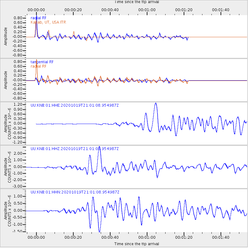
Signal To Noise
| Channel | StoN | STA | LTA |
| UU:KNB:01:HHZ:20201019T21:01:08.954987Z | 7.843387 | 2.3301972E-8 | 2.9709069E-9 |
| UU:KNB:01:HHN:20201019T21:01:08.954987Z | 2.6642327 | 8.329987E-9 | 3.126599E-9 |
| UU:KNB:01:HHE:20201019T21:01:08.954987Z | 2.6493285 | 1.1661116E-8 | 4.401536E-9 |
| Arrivals |
| Ps | 6.5 SECOND |
| PpPs | 20 SECOND |
| PsPs/PpSs | 27 SECOND |


