You are here: Home > Network List > AZ - ANZA Regional Network Stations List
> Station LVA2 AZ.LVA2 > Earthquake Result Viewer
LVA2 AZ.LVA2 - Earthquake Result Viewer
| Earthquake location: |
South Of Alaska |
| Earthquake latitude/longitude: |
54.4/-159.6 |
| Earthquake time(UTC): |
2020/10/19 (293) 21:05:57 GMT |
| Earthquake Depth: |
27 km |
| Earthquake Magnitude: |
5.8 mb |
| Earthquake Catalog/Contributor: |
NEIC PDE/us |
|
| Network: |
AZ ANZA Regional Network |
| Station: |
LVA2 AZ.LVA2 |
| Lat/Lon: |
33.35 N/116.56 W |
| Elevation: |
1435 m |
|
| Distance: |
36.7 deg |
| Az: |
107.16 deg |
| Baz: |
318.166 deg |
| Ray Param: |
0.07649664 |
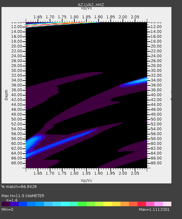
| Estimated Moho Depth: |
11.5 km |
| Estimated Crust Vp/Vs: |
1.60 |
| Assumed Crust Vp: |
6.264 km/s |
| Estimated Crust Vs: |
3.915 km/s |
| Estimated Crust Poisson's Ratio: |
0.18 |
|
| Radial Match: |
96.9429 % |
| Radial Bump: |
304 |
| Transverse Match: |
86.84512 % |
| Transverse Bump: |
400 |
| SOD ConfigId: |
22732711 |
| Insert Time: |
2020-11-02 21:26:06.271 +0000 |
| GWidth: |
2.5 |
| Max Bumps: |
400 |
| Tol: |
0.001 |
|

Signal To Noise
| Channel | StoN | STA | LTA |
| AZ:LVA2: :HHZ:20201019T21:12:32.232988Z | 0.8760273 | 1.7880644E-4 | 2.0411058E-4 |
| AZ:LVA2: :HHN:20201019T21:12:32.232988Z | 2.1791134 | 9.635176E-5 | 4.421604E-5 |
| AZ:LVA2: :HHE:20201019T21:12:32.232988Z | 1.9518561 | 2.3862653E-4 | 1.222562E-4 |
| Arrivals |
| Ps | 1.2 SECOND |
| PpPs | 4.4 SECOND |
| PsPs/PpSs | 5.6 SECOND |


