You are here: Home > Network List > GS - US Geological Survey Networks Stations List
> Station DEC08 Union Local 159 Surface Site > Earthquake Result Viewer
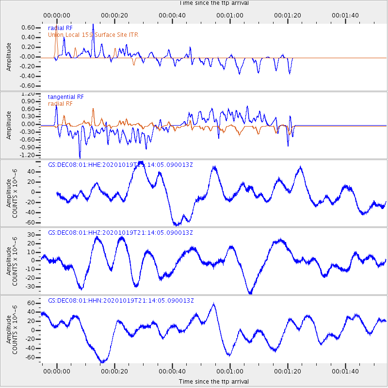
DEC08 Union Local 159 Surface Site - Earthquake Result Viewer
*The percent match for this event was below the threshold and hence no stack was calculated.
| Earthquake location: |
South Of Alaska |
| Earthquake latitude/longitude: |
54.4/-159.6 |
| Earthquake time(UTC): |
2020/10/19 (293) 21:05:57 GMT |
| Earthquake Depth: |
27 km |
| Earthquake Magnitude: |
5.8 mb |
| Earthquake Catalog/Contributor: |
NEIC PDE/us |
|
| Network: |
GS US Geological Survey Networks |
| Station: |
DEC08 Union Local 159 Surface Site |
| Lat/Lon: |
39.86 N/88.92 W |
| Elevation: |
210 m |
|
| Distance: |
48.2 deg |
| Az: |
77.083 deg |
| Baz: |
312.281 deg |
| Ray Param: |
$rayparam |
*The percent match for this event was below the threshold and hence was not used in the summary stack. |
|
| Radial Match: |
44.98752 % |
| Radial Bump: |
384 |
| Transverse Match: |
76.431435 % |
| Transverse Bump: |
400 |
| SOD ConfigId: |
22732711 |
| Insert Time: |
2020-11-02 21:30:39.094 +0000 |
| GWidth: |
2.5 |
| Max Bumps: |
400 |
| Tol: |
0.001 |
|
Signal To Noise
| Channel | StoN | STA | LTA |
| GS:DEC08:01:HHZ:20201019T21:14:05.090013Z | 0.5785167 | 5.2303417E-6 | 9.040951E-6 |
| GS:DEC08:01:HHN:20201019T21:14:05.090013Z | 0.9437997 | 1.5344123E-5 | 1.6257818E-5 |
| GS:DEC08:01:HHE:20201019T21:14:05.090013Z | 4.704066 | 4.0892428E-5 | 8.692996E-6 |
| Arrivals |
| Ps | |
| PpPs | |
| PsPs/PpSs | |


