You are here: Home > Network List > US - United States National Seismic Network Stations List
> Station MNTX Cornudas Mountains, Texas, USA > Earthquake Result Viewer
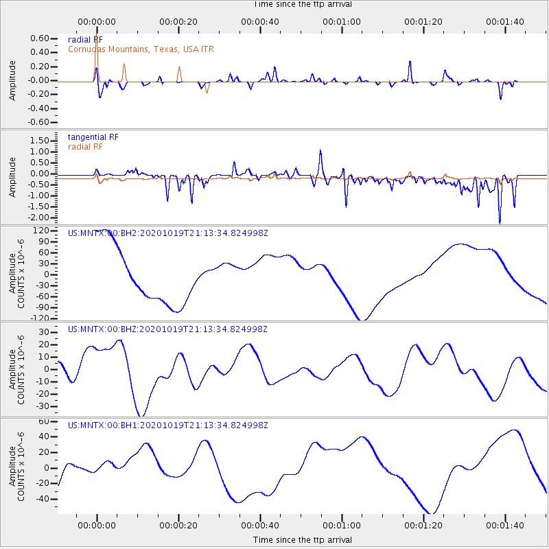
MNTX Cornudas Mountains, Texas, USA - Earthquake Result Viewer
*The percent match for this event was below the threshold and hence no stack was calculated.
| Earthquake location: |
South Of Alaska |
| Earthquake latitude/longitude: |
54.4/-159.6 |
| Earthquake time(UTC): |
2020/10/19 (293) 21:05:57 GMT |
| Earthquake Depth: |
27 km |
| Earthquake Magnitude: |
5.8 mb |
| Earthquake Catalog/Contributor: |
NEIC PDE/us |
|
| Network: |
US United States National Seismic Network |
| Station: |
MNTX Cornudas Mountains, Texas, USA |
| Lat/Lon: |
31.70 N/105.38 W |
| Elevation: |
404 m |
|
| Distance: |
44.3 deg |
| Az: |
98.115 deg |
| Baz: |
317.268 deg |
| Ray Param: |
$rayparam |
*The percent match for this event was below the threshold and hence was not used in the summary stack. |
|
| Radial Match: |
21.50642 % |
| Radial Bump: |
205 |
| Transverse Match: |
58.484745 % |
| Transverse Bump: |
393 |
| SOD ConfigId: |
22732711 |
| Insert Time: |
2020-11-02 21:40:42.414 +0000 |
| GWidth: |
2.5 |
| Max Bumps: |
400 |
| Tol: |
0.001 |
|
Signal To Noise
| Channel | StoN | STA | LTA |
| US:MNTX:00:BHZ:20201019T21:13:34.824998Z | 2.224415 | 2.0789956E-5 | 9.346258E-6 |
| US:MNTX:00:BH1:20201019T21:13:34.824998Z | 0.34871283 | 8.082413E-6 | 2.3177849E-5 |
| US:MNTX:00:BH2:20201019T21:13:34.824998Z | 0.5100512 | 3.8620332E-5 | 7.571854E-5 |
| Arrivals |
| Ps | |
| PpPs | |
| PsPs/PpSs | |


