You are here: Home > Network List > UU - University of Utah Regional Network Stations List
> Station HMU Henry Mountain, UT, USA > Earthquake Result Viewer
HMU Henry Mountain, UT, USA - Earthquake Result Viewer
| Earthquake location: |
South Of Alaska |
| Earthquake latitude/longitude: |
54.4/-159.6 |
| Earthquake time(UTC): |
2020/10/19 (293) 21:05:57 GMT |
| Earthquake Depth: |
27 km |
| Earthquake Magnitude: |
5.8 mb |
| Earthquake Catalog/Contributor: |
NEIC PDE/us |
|
| Network: |
UU University of Utah Regional Network |
| Station: |
HMU Henry Mountain, UT, USA |
| Lat/Lon: |
37.94 N/110.74 W |
| Elevation: |
2430 m |
|
| Distance: |
36.8 deg |
| Az: |
96.149 deg |
| Baz: |
312.719 deg |
| Ray Param: |
0.07645782 |
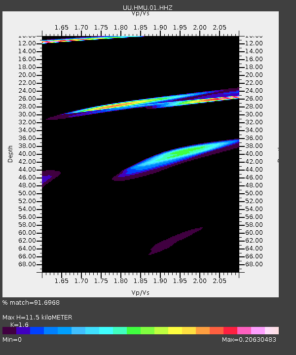
| Estimated Moho Depth: |
11.5 km |
| Estimated Crust Vp/Vs: |
1.60 |
| Assumed Crust Vp: |
6.247 km/s |
| Estimated Crust Vs: |
3.904 km/s |
| Estimated Crust Poisson's Ratio: |
0.18 |
|
| Radial Match: |
91.6968 % |
| Radial Bump: |
400 |
| Transverse Match: |
61.556133 % |
| Transverse Bump: |
400 |
| SOD ConfigId: |
22732711 |
| Insert Time: |
2020-11-02 21:40:58.934 +0000 |
| GWidth: |
2.5 |
| Max Bumps: |
400 |
| Tol: |
0.001 |
|

Signal To Noise
| Channel | StoN | STA | LTA |
| UU:HMU:01:HHZ:20201019T21:12:32.81801Z | 4.3956676 | 2.970681E-6 | 6.7582016E-7 |
| UU:HMU:01:HHN:20201019T21:12:32.81801Z | 1.4794155 | 1.6749914E-6 | 1.132198E-6 |
| UU:HMU:01:HHE:20201019T21:12:32.81801Z | 0.67996275 | 7.6379445E-7 | 1.1232886E-6 |
| Arrivals |
| Ps | 1.2 SECOND |
| PpPs | 4.4 SECOND |
| PsPs/PpSs | 5.6 SECOND |


