You are here: Home > Network List > UU - University of Utah Regional Network Stations List
> Station WPUT Wasatch Plateau, UT,USA > Earthquake Result Viewer
WPUT Wasatch Plateau, UT,USA - Earthquake Result Viewer
| Earthquake location: |
South Of Alaska |
| Earthquake latitude/longitude: |
54.4/-159.6 |
| Earthquake time(UTC): |
2020/10/19 (293) 21:05:57 GMT |
| Earthquake Depth: |
27 km |
| Earthquake Magnitude: |
5.8 mb |
| Earthquake Catalog/Contributor: |
NEIC PDE/us |
|
| Network: |
UU University of Utah Regional Network |
| Station: |
WPUT Wasatch Plateau, UT,USA |
| Lat/Lon: |
39.00 N/111.36 W |
| Elevation: |
2618 m |
|
| Distance: |
35.7 deg |
| Az: |
95.375 deg |
| Baz: |
311.713 deg |
| Ray Param: |
0.0770232 |
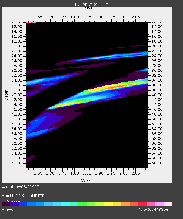
| Estimated Moho Depth: |
10.0 km |
| Estimated Crust Vp/Vs: |
1.61 |
| Assumed Crust Vp: |
6.207 km/s |
| Estimated Crust Vs: |
3.855 km/s |
| Estimated Crust Poisson's Ratio: |
0.19 |
|
| Radial Match: |
93.22627 % |
| Radial Bump: |
400 |
| Transverse Match: |
61.914387 % |
| Transverse Bump: |
385 |
| SOD ConfigId: |
22732711 |
| Insert Time: |
2020-11-02 21:41:21.901 +0000 |
| GWidth: |
2.5 |
| Max Bumps: |
400 |
| Tol: |
0.001 |
|

Signal To Noise
| Channel | StoN | STA | LTA |
| UU:WPUT:01:HHZ:20201019T21:12:23.699998Z | 0.6729051 | 1.5948555E-6 | 2.3701045E-6 |
| UU:WPUT:01:HHN:20201019T21:12:23.699998Z | 3.338526 | 5.0052677E-6 | 1.4992447E-6 |
| UU:WPUT:01:HHE:20201019T21:12:23.699998Z | 0.5446728 | 1.2052565E-6 | 2.2128083E-6 |
| Arrivals |
| Ps | 1.1 SECOND |
| PpPs | 3.9 SECOND |
| PsPs/PpSs | 5.0 SECOND |


