You are here: Home > Network List > UU - University of Utah Regional Network Stations List
> Station ZNPU Zion National Park, UT, USA > Earthquake Result Viewer
ZNPU Zion National Park, UT, USA - Earthquake Result Viewer
| Earthquake location: |
South Of Alaska |
| Earthquake latitude/longitude: |
54.4/-159.6 |
| Earthquake time(UTC): |
2020/10/19 (293) 21:05:57 GMT |
| Earthquake Depth: |
27 km |
| Earthquake Magnitude: |
5.8 mb |
| Earthquake Catalog/Contributor: |
NEIC PDE/us |
|
| Network: |
UU University of Utah Regional Network |
| Station: |
ZNPU Zion National Park, UT, USA |
| Lat/Lon: |
37.36 N/113.13 W |
| Elevation: |
1953 m |
|
| Distance: |
35.8 deg |
| Az: |
99.05 deg |
| Baz: |
313.606 deg |
| Ray Param: |
0.07698351 |
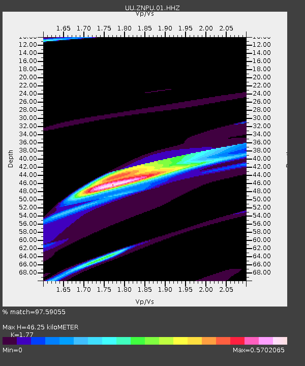
| Estimated Moho Depth: |
46.25 km |
| Estimated Crust Vp/Vs: |
1.77 |
| Assumed Crust Vp: |
6.194 km/s |
| Estimated Crust Vs: |
3.5 km/s |
| Estimated Crust Poisson's Ratio: |
0.27 |
|
| Radial Match: |
97.59055 % |
| Radial Bump: |
400 |
| Transverse Match: |
88.72893 % |
| Transverse Bump: |
400 |
| SOD ConfigId: |
22732711 |
| Insert Time: |
2020-11-02 21:41:22.297 +0000 |
| GWidth: |
2.5 |
| Max Bumps: |
400 |
| Tol: |
0.001 |
|

Signal To Noise
| Channel | StoN | STA | LTA |
| UU:ZNPU:01:HHZ:20201019T21:12:24.448014Z | 0.5497806 | 2.1174017E-6 | 3.8513576E-6 |
| UU:ZNPU:01:HHN:20201019T21:12:24.448014Z | 0.658515 | 1.9861468E-6 | 3.0160995E-6 |
| UU:ZNPU:01:HHE:20201019T21:12:24.448014Z | 2.2269185 | 5.0612366E-6 | 2.2727534E-6 |
| Arrivals |
| Ps | 6.2 SECOND |
| PpPs | 19 SECOND |
| PsPs/PpSs | 25 SECOND |


