You are here: Home > Network List > WY - Yellowstone Wyoming Seismic Network Stations List
> Station YPP Pitchstone Plateau, YNP, WY, USA > Earthquake Result Viewer
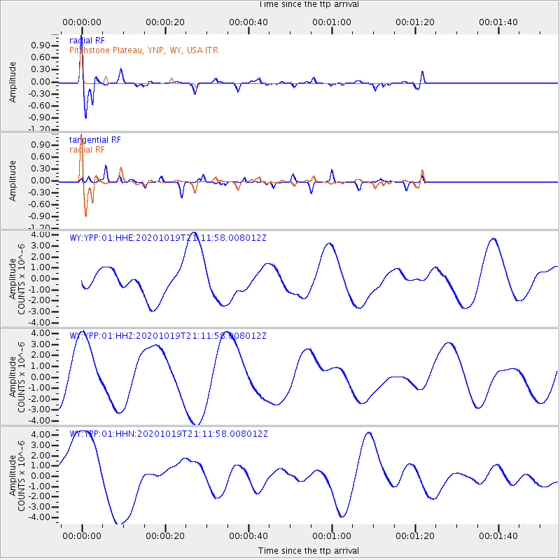
YPP Pitchstone Plateau, YNP, WY, USA - Earthquake Result Viewer
| Earthquake location: |
South Of Alaska |
| Earthquake latitude/longitude: |
54.4/-159.6 |
| Earthquake time(UTC): |
2020/10/19 (293) 21:05:57 GMT |
| Earthquake Depth: |
27 km |
| Earthquake Magnitude: |
5.8 mb |
| Earthquake Catalog/Contributor: |
NEIC PDE/us |
|
| Network: |
WY Yellowstone Wyoming Seismic Network |
| Station: |
YPP Pitchstone Plateau, YNP, WY, USA |
| Lat/Lon: |
44.27 N/110.80 W |
| Elevation: |
2707 m |
|
| Distance: |
32.8 deg |
| Az: |
87.603 deg |
| Baz: |
305.65 deg |
| Ray Param: |
0.07847654 |
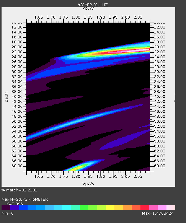
| Estimated Moho Depth: |
20.75 km |
| Estimated Crust Vp/Vs: |
2.10 |
| Assumed Crust Vp: |
6.35 km/s |
| Estimated Crust Vs: |
3.031 km/s |
| Estimated Crust Poisson's Ratio: |
0.35 |
|
| Radial Match: |
82.2181 % |
| Radial Bump: |
400 |
| Transverse Match: |
29.702885 % |
| Transverse Bump: |
132 |
| SOD ConfigId: |
22732711 |
| Insert Time: |
2020-11-02 21:42:04.380 +0000 |
| GWidth: |
2.5 |
| Max Bumps: |
400 |
| Tol: |
0.001 |
|
Signal To Noise
| Channel | StoN | STA | LTA |
| WY:YPP:01:HHZ:20201019T21:11:58.008012Z | 1.375844 | 2.9783278E-6 | 2.1647277E-6 |
| WY:YPP:01:HHN:20201019T21:11:58.008012Z | 3.4379728 | 4.596026E-6 | 1.3368419E-6 |
| WY:YPP:01:HHE:20201019T21:11:58.008012Z | 1.3416559 | 1.6263542E-6 | 1.2121992E-6 |
| Arrivals |
| Ps | 3.8 SECOND |
| PpPs | 9.5 SECOND |
| PsPs/PpSs | 13 SECOND |


