You are here: Home > Network List > CU - Caribbean Network (USGS) Stations List
> Station BBGH Gun Hill, Barbados > Earthquake Result Viewer
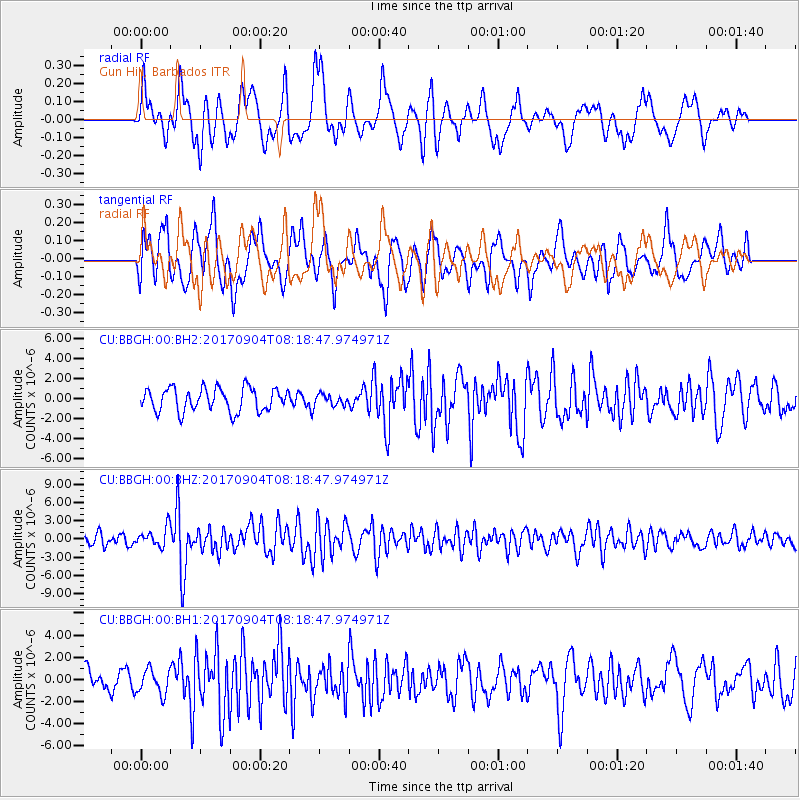
BBGH Gun Hill, Barbados - Earthquake Result Viewer
*The percent match for this event was below the threshold and hence no stack was calculated.
| Earthquake location: |
South Sandwich Islands Region |
| Earthquake latitude/longitude: |
-57.8/-25.6 |
| Earthquake time(UTC): |
2017/09/04 (247) 08:07:35 GMT |
| Earthquake Depth: |
35 km |
| Earthquake Magnitude: |
6.0 Mww |
| Earthquake Catalog/Contributor: |
NEIC PDE/us |
|
| Network: |
CU Caribbean Network (USGS) |
| Station: |
BBGH Gun Hill, Barbados |
| Lat/Lon: |
13.14 N/59.56 W |
| Elevation: |
180 m |
|
| Distance: |
76.0 deg |
| Az: |
325.867 deg |
| Baz: |
162.03 deg |
| Ray Param: |
$rayparam |
*The percent match for this event was below the threshold and hence was not used in the summary stack. |
|
| Radial Match: |
68.798294 % |
| Radial Bump: |
400 |
| Transverse Match: |
66.05575 % |
| Transverse Bump: |
400 |
| SOD ConfigId: |
2307692 |
| Insert Time: |
2017-09-18 08:08:22.975 +0000 |
| GWidth: |
2.5 |
| Max Bumps: |
400 |
| Tol: |
0.001 |
|
Signal To Noise
| Channel | StoN | STA | LTA |
| CU:BBGH:00:BHZ:20170904T08:18:47.974971Z | 1.9101936 | 1.5786475E-6 | 8.264332E-7 |
| CU:BBGH:00:BH1:20170904T08:18:47.974971Z | 1.5131408 | 1.1137781E-6 | 7.360703E-7 |
| CU:BBGH:00:BH2:20170904T08:18:47.974971Z | 0.46724644 | 5.3980364E-7 | 1.1552868E-6 |
| Arrivals |
| Ps | |
| PpPs | |
| PsPs/PpSs | |


