You are here: Home > Network List > UU - University of Utah Regional Network Stations List
> Station MPU Maple Canyon, UT, USA > Earthquake Result Viewer
MPU Maple Canyon, UT, USA - Earthquake Result Viewer
| Earthquake location: |
South Of Alaska |
| Earthquake latitude/longitude: |
54.5/-159.7 |
| Earthquake time(UTC): |
2020/10/19 (293) 21:06:20 GMT |
| Earthquake Depth: |
26 km |
| Earthquake Magnitude: |
5.7 mb |
| Earthquake Catalog/Contributor: |
NEIC PDE/us |
|
| Network: |
UU University of Utah Regional Network |
| Station: |
MPU Maple Canyon, UT, USA |
| Lat/Lon: |
40.02 N/111.63 W |
| Elevation: |
1909 m |
|
| Distance: |
35.0 deg |
| Az: |
94.319 deg |
| Baz: |
310.782 deg |
| Ray Param: |
0.07743062 |
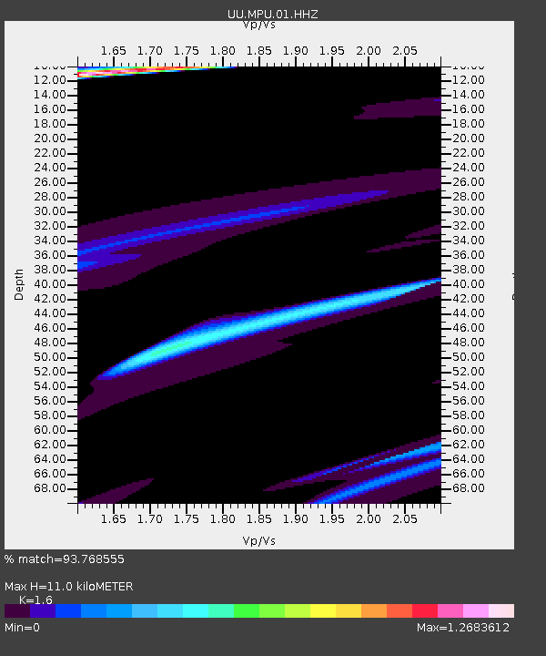
| Estimated Moho Depth: |
11.0 km |
| Estimated Crust Vp/Vs: |
1.60 |
| Assumed Crust Vp: |
6.155 km/s |
| Estimated Crust Vs: |
3.847 km/s |
| Estimated Crust Poisson's Ratio: |
0.18 |
|
| Radial Match: |
93.768555 % |
| Radial Bump: |
370 |
| Transverse Match: |
56.50248 % |
| Transverse Bump: |
400 |
| SOD ConfigId: |
22732711 |
| Insert Time: |
2020-11-02 21:57:28.590 +0000 |
| GWidth: |
2.5 |
| Max Bumps: |
400 |
| Tol: |
0.001 |
|

Signal To Noise
| Channel | StoN | STA | LTA |
| UU:MPU:01:HHZ:20201019T21:12:39.755002Z | 1.7626303 | 3.739566E-6 | 2.1215826E-6 |
| UU:MPU:01:HHN:20201019T21:12:39.755002Z | 1.3247172 | 1.8445724E-6 | 1.3924273E-6 |
| UU:MPU:01:HHE:20201019T21:12:39.755002Z | 0.836636 | 2.6379164E-6 | 3.1530037E-6 |
| Arrivals |
| Ps | 1.2 SECOND |
| PpPs | 4.3 SECOND |
| PsPs/PpSs | 5.5 SECOND |


