You are here: Home > Network List > UU - University of Utah Regional Network Stations List
> Station WPUT Wasatch Plateau, UT,USA > Earthquake Result Viewer
WPUT Wasatch Plateau, UT,USA - Earthquake Result Viewer
| Earthquake location: |
South Of Alaska |
| Earthquake latitude/longitude: |
54.5/-159.7 |
| Earthquake time(UTC): |
2020/10/19 (293) 21:06:20 GMT |
| Earthquake Depth: |
26 km |
| Earthquake Magnitude: |
5.7 mb |
| Earthquake Catalog/Contributor: |
NEIC PDE/us |
|
| Network: |
UU University of Utah Regional Network |
| Station: |
WPUT Wasatch Plateau, UT,USA |
| Lat/Lon: |
39.00 N/111.36 W |
| Elevation: |
2618 m |
|
| Distance: |
35.8 deg |
| Az: |
95.396 deg |
| Baz: |
311.833 deg |
| Ray Param: |
0.07699793 |
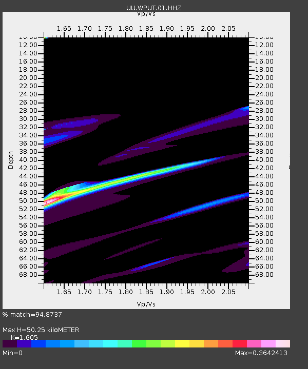
| Estimated Moho Depth: |
50.25 km |
| Estimated Crust Vp/Vs: |
1.61 |
| Assumed Crust Vp: |
6.207 km/s |
| Estimated Crust Vs: |
3.867 km/s |
| Estimated Crust Poisson's Ratio: |
0.18 |
|
| Radial Match: |
94.8737 % |
| Radial Bump: |
381 |
| Transverse Match: |
63.32178 % |
| Transverse Bump: |
356 |
| SOD ConfigId: |
22732711 |
| Insert Time: |
2020-11-02 21:57:41.777 +0000 |
| GWidth: |
2.5 |
| Max Bumps: |
400 |
| Tol: |
0.001 |
|

Signal To Noise
| Channel | StoN | STA | LTA |
| UU:WPUT:01:HHZ:20201019T21:12:46.869992Z | 1.0007892 | 2.3967204E-6 | 2.3948305E-6 |
| UU:WPUT:01:HHN:20201019T21:12:46.869992Z | 0.7950541 | 2.5951047E-6 | 3.2640605E-6 |
| UU:WPUT:01:HHE:20201019T21:12:46.869992Z | 2.5548255 | 5.0947438E-6 | 1.994165E-6 |
| Arrivals |
| Ps | 5.3 SECOND |
| PpPs | 20 SECOND |
| PsPs/PpSs | 25 SECOND |


