You are here: Home > Network List > TX - Texas Seismological Network Stations List
> Station FW11 UT at Arlington > Earthquake Result Viewer
FW11 UT at Arlington - Earthquake Result Viewer
| Earthquake location: |
South Of Alaska |
| Earthquake latitude/longitude: |
54.2/-159.7 |
| Earthquake time(UTC): |
2020/10/19 (293) 21:32:19 GMT |
| Earthquake Depth: |
16 km |
| Earthquake Magnitude: |
5.5 Mww |
| Earthquake Catalog/Contributor: |
NEIC PDE/us |
|
| Network: |
TX Texas Seismological Network |
| Station: |
FW11 UT at Arlington |
| Lat/Lon: |
32.72 N/97.13 W |
| Elevation: |
198 m |
|
| Distance: |
48.4 deg |
| Az: |
89.927 deg |
| Baz: |
315.865 deg |
| Ray Param: |
0.069371074 |
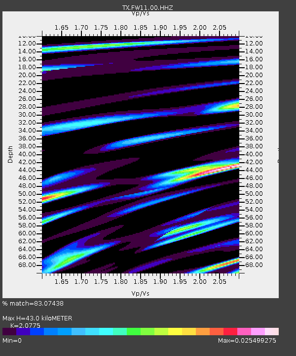
| Estimated Moho Depth: |
43.0 km |
| Estimated Crust Vp/Vs: |
2.08 |
| Assumed Crust Vp: |
6.38 km/s |
| Estimated Crust Vs: |
3.071 km/s |
| Estimated Crust Poisson's Ratio: |
0.35 |
|
| Radial Match: |
83.07438 % |
| Radial Bump: |
400 |
| Transverse Match: |
99.93356 % |
| Transverse Bump: |
13 |
| SOD ConfigId: |
22732711 |
| Insert Time: |
2020-11-02 22:10:58.860 +0000 |
| GWidth: |
2.5 |
| Max Bumps: |
400 |
| Tol: |
0.001 |
|

Signal To Noise
| Channel | StoN | STA | LTA |
| TX:FW11:00:HHZ:20201019T21:40:30.12001Z | 6.6020603 | 6.601175E-8 | 9.99866E-9 |
| TX:FW11:00:HH1:20201019T21:40:30.12001Z | 6.5108533 | 3.0920358E-8 | 4.7490487E-9 |
| TX:FW11:00:HH2:20201019T21:40:30.12001Z | 6.494507 | 3.42229E-8 | 5.2695146E-9 |
| Arrivals |
| Ps | 7.6 SECOND |
| PpPs | 20 SECOND |
| PsPs/PpSs | 27 SECOND |


