You are here: Home > Network List > US - United States National Seismic Network Stations List
> Station EGMT Eagleton, Montana, USA > Earthquake Result Viewer
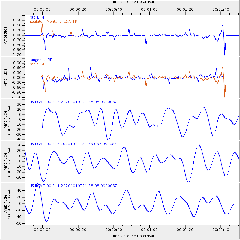
EGMT Eagleton, Montana, USA - Earthquake Result Viewer
*The percent match for this event was below the threshold and hence no stack was calculated.
| Earthquake location: |
South Of Alaska |
| Earthquake latitude/longitude: |
54.2/-159.7 |
| Earthquake time(UTC): |
2020/10/19 (293) 21:32:19 GMT |
| Earthquake Depth: |
16 km |
| Earthquake Magnitude: |
5.5 Mww |
| Earthquake Catalog/Contributor: |
NEIC PDE/us |
|
| Network: |
US United States National Seismic Network |
| Station: |
EGMT Eagleton, Montana, USA |
| Lat/Lon: |
48.02 N/109.75 W |
| Elevation: |
1055 m |
|
| Distance: |
31.4 deg |
| Az: |
80.602 deg |
| Baz: |
300.383 deg |
| Ray Param: |
$rayparam |
*The percent match for this event was below the threshold and hence was not used in the summary stack. |
|
| Radial Match: |
64.33124 % |
| Radial Bump: |
400 |
| Transverse Match: |
74.61487 % |
| Transverse Bump: |
400 |
| SOD ConfigId: |
22732711 |
| Insert Time: |
2020-11-02 22:11:34.928 +0000 |
| GWidth: |
2.5 |
| Max Bumps: |
400 |
| Tol: |
0.001 |
|
Signal To Noise
| Channel | StoN | STA | LTA |
| US:EGMT:00:BHZ:20201019T21:38:08.999008Z | 1.424482 | 2.6074458E-5 | 1.830452E-5 |
| US:EGMT:00:BH1:20201019T21:38:08.999008Z | 1.8398058 | 3.4068442E-5 | 1.8517412E-5 |
| US:EGMT:00:BH2:20201019T21:38:08.999008Z | 0.80294967 | 1.3298841E-5 | 1.6562484E-5 |
| Arrivals |
| Ps | |
| PpPs | |
| PsPs/PpSs | |


