You are here: Home > Network List > IU - Global Seismograph Network (GSN - IRIS/USGS) Stations List
> Station JOHN Johnston Island, USA > Earthquake Result Viewer
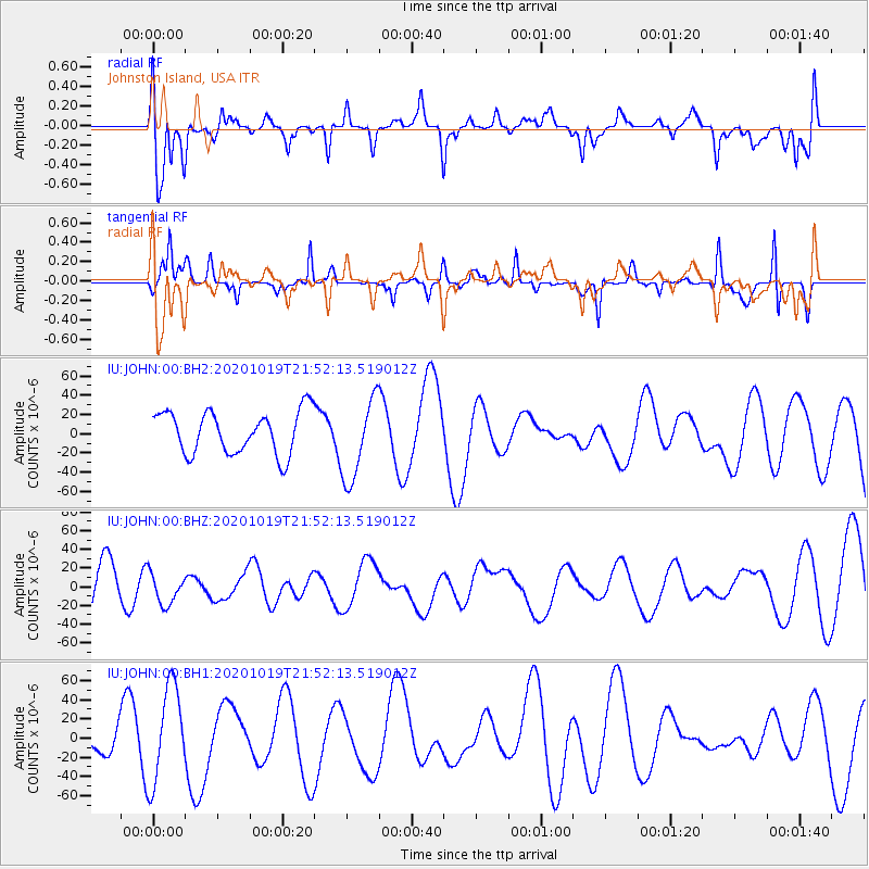
JOHN Johnston Island, USA - Earthquake Result Viewer
*The percent match for this event was below the threshold and hence no stack was calculated.
| Earthquake location: |
South Of Alaska |
| Earthquake latitude/longitude: |
54.3/-159.9 |
| Earthquake time(UTC): |
2020/10/19 (293) 21:45:25 GMT |
| Earthquake Depth: |
24 km |
| Earthquake Magnitude: |
5.9 mww |
| Earthquake Catalog/Contributor: |
NEIC PDE/us |
|
| Network: |
IU Global Seismograph Network (GSN - IRIS/USGS) |
| Station: |
JOHN Johnston Island, USA |
| Lat/Lon: |
16.73 N/169.53 W |
| Elevation: |
2.0 m |
|
| Distance: |
38.3 deg |
| Az: |
195.059 deg |
| Baz: |
9.134 deg |
| Ray Param: |
$rayparam |
*The percent match for this event was below the threshold and hence was not used in the summary stack. |
|
| Radial Match: |
55.27715 % |
| Radial Bump: |
400 |
| Transverse Match: |
61.808834 % |
| Transverse Bump: |
289 |
| SOD ConfigId: |
22732711 |
| Insert Time: |
2020-11-02 22:18:43.138 +0000 |
| GWidth: |
2.5 |
| Max Bumps: |
400 |
| Tol: |
0.001 |
|
Signal To Noise
| Channel | StoN | STA | LTA |
| IU:JOHN:00:BHZ:20201019T21:52:13.519012Z | 0.71076804 | 1.6818063E-5 | 2.3661816E-5 |
| IU:JOHN:00:BH1:20201019T21:52:13.519012Z | 4.2404513 | 5.0194787E-5 | 1.1837133E-5 |
| IU:JOHN:00:BH2:20201019T21:52:13.519012Z | 1.9338467 | 4.2720472E-5 | 2.209093E-5 |
| Arrivals |
| Ps | |
| PpPs | |
| PsPs/PpSs | |


