You are here: Home > Network List > CI - Caltech Regional Seismic Network Stations List
> Station MPP McPhearson Peak > Earthquake Result Viewer
MPP McPhearson Peak - Earthquake Result Viewer
*The percent match for this event was below the threshold and hence no stack was calculated.
| Earthquake location: |
South Of Alaska |
| Earthquake latitude/longitude: |
54.3/-159.7 |
| Earthquake time(UTC): |
2020/10/20 (294) 04:07:06 GMT |
| Earthquake Depth: |
6.1 km |
| Earthquake Magnitude: |
5.6 mww |
| Earthquake Catalog/Contributor: |
NEIC PDE/us |
|
| Network: |
CI Caltech Regional Seismic Network |
| Station: |
MPP McPhearson Peak |
| Lat/Lon: |
34.89 N/119.81 W |
| Elevation: |
1739 m |
|
| Distance: |
33.8 deg |
| Az: |
108.625 deg |
| Baz: |
317.504 deg |
| Ray Param: |
$rayparam |
*The percent match for this event was below the threshold and hence was not used in the summary stack. |
|
| Radial Match: |
72.336075 % |
| Radial Bump: |
400 |
| Transverse Match: |
66.20894 % |
| Transverse Bump: |
400 |
| SOD ConfigId: |
22732711 |
| Insert Time: |
2020-11-03 04:10:48.225 +0000 |
| GWidth: |
2.5 |
| Max Bumps: |
400 |
| Tol: |
0.001 |
|
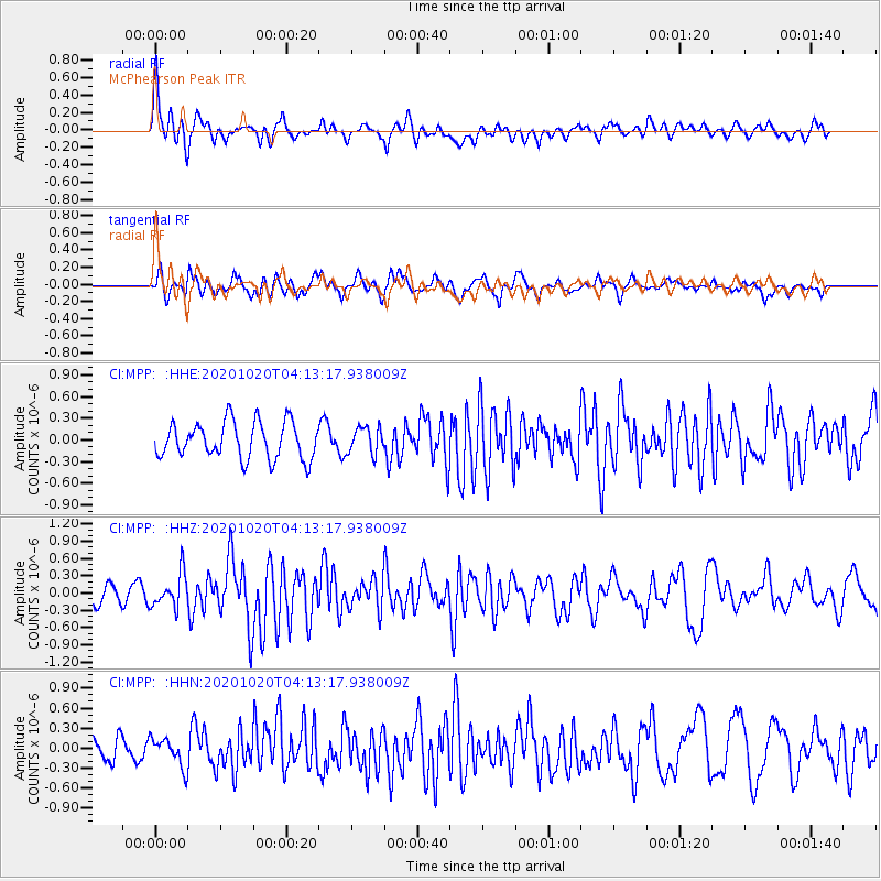
Signal To Noise
| Channel | StoN | STA | LTA |
| CI:MPP: :HHZ:20201020T04:13:17.938009Z | 1.9454464 | 2.9059552E-7 | 1.4937216E-7 |
| CI:MPP: :HHN:20201020T04:13:17.938009Z | 1.2912745 | 2.1500995E-7 | 1.6650986E-7 |
| CI:MPP: :HHE:20201020T04:13:17.938009Z | 0.7253221 | 1.8303595E-7 | 2.5235124E-7 |
| Arrivals |
| Ps | |
| PpPs | |
| PsPs/PpSs | |


