You are here: Home > Network List > WI - West Indies IPGP Network Stations List
> Station BIM Morne Bigot, Anses d'Arlets, Martinique > Earthquake Result Viewer
BIM Morne Bigot, Anses d'Arlets, Martinique - Earthquake Result Viewer
| Earthquake location: |
South Sandwich Islands Region |
| Earthquake latitude/longitude: |
-57.8/-25.6 |
| Earthquake time(UTC): |
2017/09/04 (247) 08:07:35 GMT |
| Earthquake Depth: |
35 km |
| Earthquake Magnitude: |
6.0 Mww |
| Earthquake Catalog/Contributor: |
NEIC PDE/us |
|
| Network: |
WI West Indies IPGP Network |
| Station: |
BIM Morne Bigot, Anses d'Arlets, Martinique |
| Lat/Lon: |
14.52 N/61.07 W |
| Elevation: |
391 m |
|
| Distance: |
77.8 deg |
| Az: |
324.879 deg |
| Baz: |
161.448 deg |
| Ray Param: |
0.050052494 |
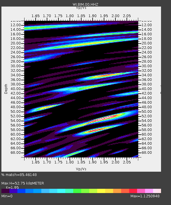
| Estimated Moho Depth: |
52.75 km |
| Estimated Crust Vp/Vs: |
1.95 |
| Assumed Crust Vp: |
5.88 km/s |
| Estimated Crust Vs: |
3.016 km/s |
| Estimated Crust Poisson's Ratio: |
0.32 |
|
| Radial Match: |
85.46148 % |
| Radial Bump: |
400 |
| Transverse Match: |
86.99186 % |
| Transverse Bump: |
400 |
| SOD ConfigId: |
2307692 |
| Insert Time: |
2017-09-18 08:10:29.805 +0000 |
| GWidth: |
2.5 |
| Max Bumps: |
400 |
| Tol: |
0.001 |
|

Signal To Noise
| Channel | StoN | STA | LTA |
| WI:BIM:00:HHZ:20170904T08:18:57.820002Z | 30.20115 | 4.793844E-6 | 1.587305E-7 |
| WI:BIM:00:HHN:20170904T08:18:57.820002Z | 10.836592 | 1.983442E-6 | 1.8303189E-7 |
| WI:BIM:00:HHE:20170904T08:18:57.820002Z | 4.781229 | 1.1202052E-6 | 2.342923E-7 |
| Arrivals |
| Ps | 8.7 SECOND |
| PpPs | 26 SECOND |
| PsPs/PpSs | 35 SECOND |


