You are here: Home > Network List > KR - Kyrgyz Digital Network Stations List
> Station TRKS Terek-Say, Kyrgyzstan > Earthquake Result Viewer
TRKS Terek-Say, Kyrgyzstan - Earthquake Result Viewer
| Earthquake location: |
South Of Alaska |
| Earthquake latitude/longitude: |
54.3/-159.7 |
| Earthquake time(UTC): |
2020/10/20 (294) 04:07:06 GMT |
| Earthquake Depth: |
6.1 km |
| Earthquake Magnitude: |
5.6 mww |
| Earthquake Catalog/Contributor: |
NEIC PDE/us |
|
| Network: |
KR Kyrgyz Digital Network |
| Station: |
TRKS Terek-Say, Kyrgyzstan |
| Lat/Lon: |
41.46 N/71.17 E |
| Elevation: |
1518 m |
|
| Distance: |
75.1 deg |
| Az: |
322.912 deg |
| Baz: |
28.047 deg |
| Ray Param: |
0.05187616 |
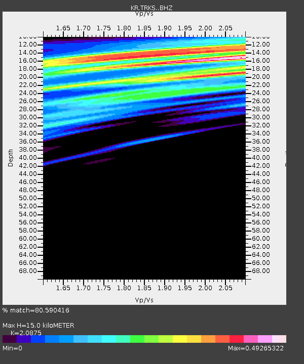
| Estimated Moho Depth: |
15.0 km |
| Estimated Crust Vp/Vs: |
2.09 |
| Assumed Crust Vp: |
6.236 km/s |
| Estimated Crust Vs: |
2.987 km/s |
| Estimated Crust Poisson's Ratio: |
0.35 |
|
| Radial Match: |
80.590416 % |
| Radial Bump: |
400 |
| Transverse Match: |
61.981915 % |
| Transverse Bump: |
400 |
| SOD ConfigId: |
22732711 |
| Insert Time: |
2020-11-03 04:17:18.549 +0000 |
| GWidth: |
2.5 |
| Max Bumps: |
400 |
| Tol: |
0.001 |
|

Signal To Noise
| Channel | StoN | STA | LTA |
| KR:TRKS: :BHZ:20201020T04:18:17.760Z | 9.471664 | 2.8042973E-7 | 2.9607227E-8 |
| KR:TRKS: :BHN:20201020T04:18:17.760Z | 3.2891905 | 2.3118692E-7 | 7.028687E-8 |
| KR:TRKS: :BHE:20201020T04:18:17.760Z | 2.4331055 | 2.0117068E-7 | 8.268062E-8 |
| Arrivals |
| Ps | 2.7 SECOND |
| PpPs | 7.2 SECOND |
| PsPs/PpSs | 9.9 SECOND |


