You are here: Home > Network List > LD - Lamont-Doherty Cooperative Seismographic Network Stations List
> Station BRNJ Basking Ridge, New Jersey > Earthquake Result Viewer
BRNJ Basking Ridge, New Jersey - Earthquake Result Viewer
| Earthquake location: |
East Of Kuril Islands |
| Earthquake latitude/longitude: |
46.2/154.5 |
| Earthquake time(UTC): |
2007/01/13 (013) 04:23:21 GMT |
| Earthquake Depth: |
10 km |
| Earthquake Magnitude: |
7.3 MB, 8.2 MS, 8.1 MW, 7.9 MW |
| Earthquake Catalog/Contributor: |
WHDF/NEIC |
|
| Network: |
LD Lamont-Doherty Cooperative Seismographic Network |
| Station: |
BRNJ Basking Ridge, New Jersey |
| Lat/Lon: |
40.68 N/74.57 W |
| Elevation: |
50 m |
|
| Distance: |
83.0 deg |
| Az: |
35.384 deg |
| Baz: |
328.1 deg |
| Ray Param: |
0.04649656 |
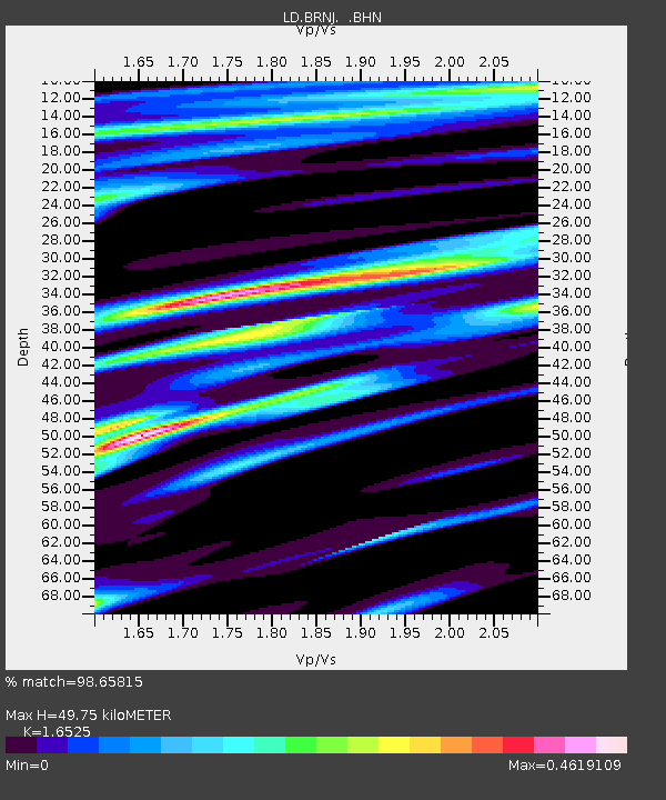
| Estimated Moho Depth: |
49.75 km |
| Estimated Crust Vp/Vs: |
1.65 |
| Assumed Crust Vp: |
6.283 km/s |
| Estimated Crust Vs: |
3.802 km/s |
| Estimated Crust Poisson's Ratio: |
0.21 |
|
| Radial Match: |
98.65815 % |
| Radial Bump: |
277 |
| Transverse Match: |
93.26148 % |
| Transverse Bump: |
310 |
| SOD ConfigId: |
2564 |
| Insert Time: |
2010-03-09 02:13:18.675 +0000 |
| GWidth: |
2.5 |
| Max Bumps: |
400 |
| Tol: |
0.001 |
|
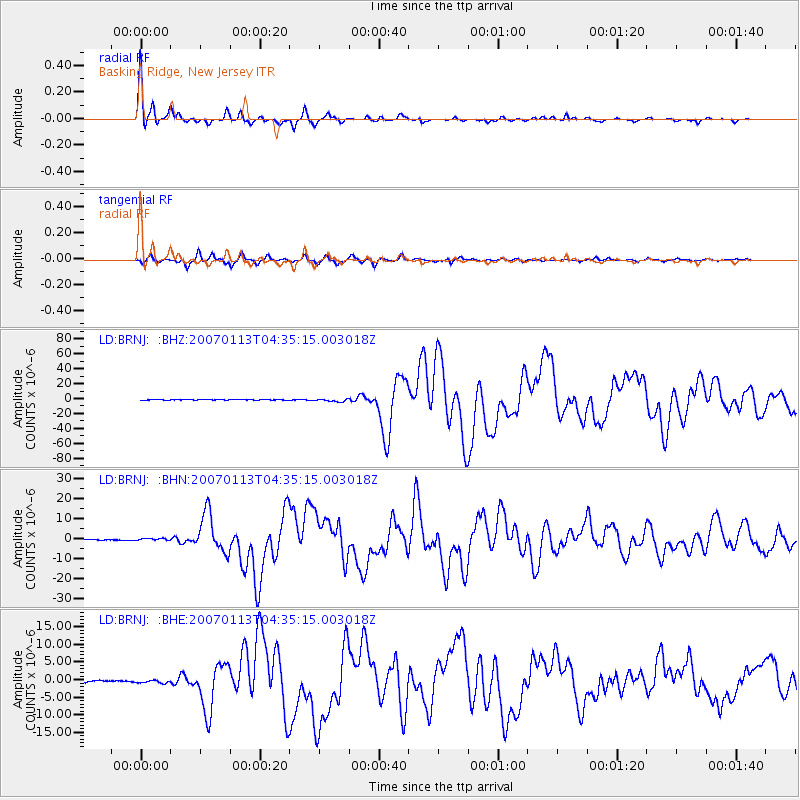
Signal To Noise
| Channel | StoN | STA | LTA |
| LD:BRNJ: :BHN:20070113T04:35:15.003018Z | 2.8802657 | 5.3951516E-7 | 1.8731436E-7 |
| LD:BRNJ: :BHE:20070113T04:35:15.003018Z | 1.6600827 | 4.94975E-7 | 2.9816286E-7 |
| LD:BRNJ: :BHZ:20070113T04:35:15.003018Z | 5.794695 | 1.8678579E-6 | 3.223393E-7 |
| Arrivals |
| Ps | 5.3 SECOND |
| PpPs | 20 SECOND |
| PsPs/PpSs | 26 SECOND |


