You are here: Home > Network List > LD - Lamont-Doherty Cooperative Seismographic Network Stations List
> Station BRNJ Basking Ridge, New Jersey > Earthquake Result Viewer
BRNJ Basking Ridge, New Jersey - Earthquake Result Viewer
| Earthquake location: |
East Of Kuril Islands |
| Earthquake latitude/longitude: |
44.1/154.7 |
| Earthquake time(UTC): |
2006/11/15 (319) 11:48:04 GMT |
| Earthquake Depth: |
10 km |
| Earthquake Magnitude: |
5.5 MB |
| Earthquake Catalog/Contributor: |
WHDF/NEIC |
|
| Network: |
LD Lamont-Doherty Cooperative Seismographic Network |
| Station: |
BRNJ Basking Ridge, New Jersey |
| Lat/Lon: |
40.68 N/74.57 W |
| Elevation: |
50 m |
|
| Distance: |
84.7 deg |
| Az: |
35.363 deg |
| Baz: |
326.753 deg |
| Ray Param: |
0.045314595 |
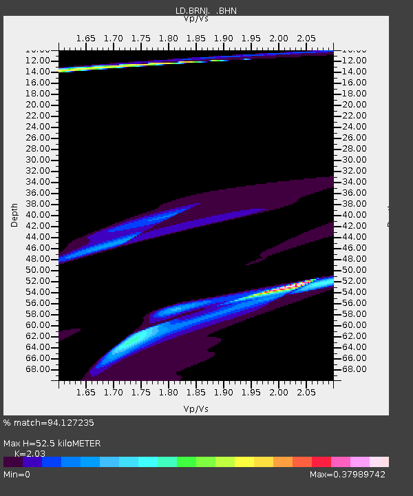
| Estimated Moho Depth: |
52.5 km |
| Estimated Crust Vp/Vs: |
2.03 |
| Assumed Crust Vp: |
6.283 km/s |
| Estimated Crust Vs: |
3.095 km/s |
| Estimated Crust Poisson's Ratio: |
0.34 |
|
| Radial Match: |
94.127235 % |
| Radial Bump: |
400 |
| Transverse Match: |
65.46853 % |
| Transverse Bump: |
230 |
| SOD ConfigId: |
2564 |
| Insert Time: |
2010-03-09 02:13:28.388 +0000 |
| GWidth: |
2.5 |
| Max Bumps: |
400 |
| Tol: |
0.001 |
|

Signal To Noise
| Channel | StoN | STA | LTA |
| LD:BRNJ: :BHN:20061115T12:00:06.578022Z | 1.0217075 | 6.4114094E-5 | 6.275191E-5 |
| LD:BRNJ: :BHE:20061115T12:00:06.578022Z | 2.3491194 | 8.2171005E-5 | 3.4979494E-5 |
| LD:BRNJ: :BHZ:20061115T12:00:06.578022Z | 1.2816246 | 9.4491916E-5 | 7.372823E-5 |
| Arrivals |
| Ps | 8.8 SECOND |
| PpPs | 25 SECOND |
| PsPs/PpSs | 34 SECOND |


