You are here: Home > Network List > LD - Lamont-Doherty Cooperative Seismographic Network Stations List
> Station BRNJ Basking Ridge, New Jersey > Earthquake Result Viewer
BRNJ Basking Ridge, New Jersey - Earthquake Result Viewer
| Earthquake location: |
Kuril Islands |
| Earthquake latitude/longitude: |
46.6/153.3 |
| Earthquake time(UTC): |
2006/11/15 (319) 11:14:13 GMT |
| Earthquake Depth: |
10 km |
| Earthquake Magnitude: |
6.5 MB, 7.8 MS, 8.3 MW, 7.9 MW |
| Earthquake Catalog/Contributor: |
WHDF/NEIC |
|
| Network: |
LD Lamont-Doherty Cooperative Seismographic Network |
| Station: |
BRNJ Basking Ridge, New Jersey |
| Lat/Lon: |
40.68 N/74.57 W |
| Elevation: |
50 m |
|
| Distance: |
83.2 deg |
| Az: |
34.586 deg |
| Baz: |
329.02 deg |
| Ray Param: |
0.04634849 |
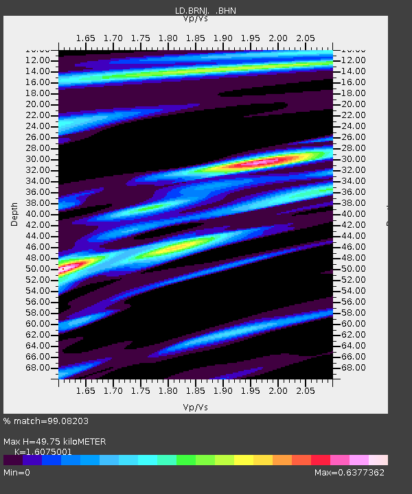
| Estimated Moho Depth: |
49.75 km |
| Estimated Crust Vp/Vs: |
1.61 |
| Assumed Crust Vp: |
6.283 km/s |
| Estimated Crust Vs: |
3.909 km/s |
| Estimated Crust Poisson's Ratio: |
0.18 |
|
| Radial Match: |
99.08203 % |
| Radial Bump: |
259 |
| Transverse Match: |
94.84769 % |
| Transverse Bump: |
400 |
| SOD ConfigId: |
2564 |
| Insert Time: |
2010-03-09 02:13:29.784 +0000 |
| GWidth: |
2.5 |
| Max Bumps: |
400 |
| Tol: |
0.001 |
|
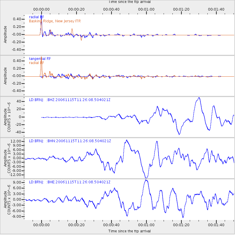
Signal To Noise
| Channel | StoN | STA | LTA |
| LD:BRNJ: :BHN:20061115T11:26:08.504021Z | 1.798921 | 5.7001586E-7 | 3.1686542E-7 |
| LD:BRNJ: :BHE:20061115T11:26:08.504021Z | 2.6217413 | 6.071087E-7 | 2.3156697E-7 |
| LD:BRNJ: :BHZ:20061115T11:26:08.504021Z | 4.1579456 | 1.6345629E-6 | 3.9311792E-7 |
| Arrivals |
| Ps | 4.9 SECOND |
| PpPs | 20 SECOND |
| PsPs/PpSs | 25 SECOND |


