You are here: Home > Network List > LD - Lamont-Doherty Cooperative Seismographic Network Stations List
> Station BRNJ Basking Ridge, New Jersey > Earthquake Result Viewer
BRNJ Basking Ridge, New Jersey - Earthquake Result Viewer

| Earthquake location: |
Western Iran |
| Earthquake latitude/longitude: |
35.6/49.0 |
| Earthquake time(UTC): |
2002/06/22 (173) 02:58:21 GMT |
| Earthquake Depth: |
10 km |
| Earthquake Magnitude: |
6.2 MB, 6.4 MS, 6.5 MW, 6.5 MW |
| Earthquake Catalog/Contributor: |
WHDF/NEIC |
|
| Network: |
LD Lamont-Doherty Cooperative Seismographic Network |
| Station: |
BRNJ Basking Ridge, New Jersey |
| Lat/Lon: |
40.68 N/74.57 W |
| Elevation: |
50 m |
|
| Distance: |
88.1 deg |
| Az: |
320.677 deg |
| Baz: |
42.754 deg |
| Ray Param: |
0.042856295 |
| Estimated Moho Depth: |
11.25 km |
| Estimated Crust Vp/Vs: |
1.85 |
| Assumed Crust Vp: |
6.283 km/s |
| Estimated Crust Vs: |
3.396 km/s |
| Estimated Crust Poisson's Ratio: |
0.29 |
|
| Radial Match: |
94.79603 % |
| Radial Bump: |
400 |
| Transverse Match: |
89.30646 % |
| Transverse Bump: |
400 |
| SOD ConfigId: |
20082 |
| Insert Time: |
2010-03-09 02:13:50.699 +0000 |
| GWidth: |
2.5 |
| Max Bumps: |
400 |
| Tol: |
0.001 |
|
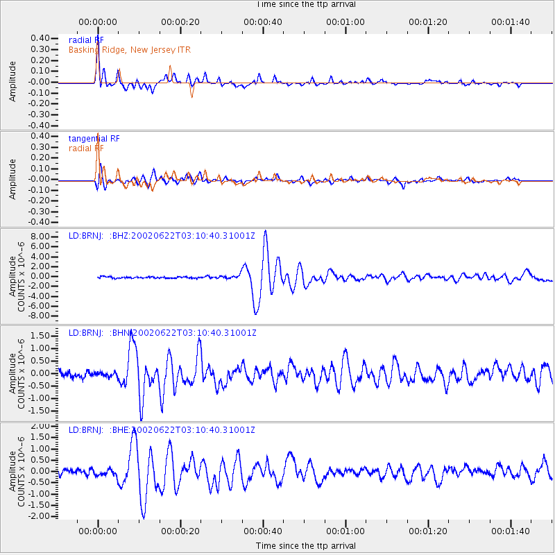
Signal To Noise
| Channel | StoN | STA | LTA |
| LD:BRNJ: :BHN:20020622T03:10:40.31001Z | 0.78887963 | 8.004621E-8 | 1.0146822E-7 |
| LD:BRNJ: :BHE:20020622T03:10:40.31001Z | 1.2124773 | 1.4479939E-7 | 1.1942441E-7 |
| LD:BRNJ: :BHZ:20020622T03:10:40.31001Z | 2.9324143 | 4.0934614E-7 | 1.3959357E-7 |
| Arrivals |
| Ps | 1.6 SECOND |
| PpPs | 5.0 SECOND |
| PsPs/PpSs | 6.6 SECOND |


