You are here: Home > Network List > LD - Lamont-Doherty Cooperative Seismographic Network Stations List
> Station BRNJ Basking Ridge, New Jersey > Earthquake Result Viewer
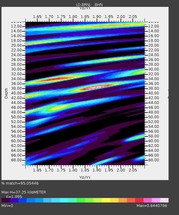
BRNJ Basking Ridge, New Jersey - Earthquake Result Viewer
| Earthquake location: |
Eastern Honshu, Japan |
| Earthquake latitude/longitude: |
39.8/141.5 |
| Earthquake time(UTC): |
2008/07/23 (205) 15:26:19 GMT |
| Earthquake Depth: |
108 km |
| Earthquake Magnitude: |
6.6 MB, 6.8 MW, 6.8 MW |
| Earthquake Catalog/Contributor: |
WHDF/NEIC |
|
| Network: |
LD Lamont-Doherty Cooperative Seismographic Network |
| Station: |
BRNJ Basking Ridge, New Jersey |
| Lat/Lon: |
40.68 N/74.57 W |
| Elevation: |
50 m |
|
| Distance: |
93.4 deg |
| Az: |
26.624 deg |
| Baz: |
333.003 deg |
| Ray Param: |
0.04120443 |
| Estimated Moho Depth: |
37.25 km |
| Estimated Crust Vp/Vs: |
1.89 |
| Assumed Crust Vp: |
6.283 km/s |
| Estimated Crust Vs: |
3.316 km/s |
| Estimated Crust Poisson's Ratio: |
0.31 |
|
| Radial Match: |
95.05446 % |
| Radial Bump: |
400 |
| Transverse Match: |
88.62134 % |
| Transverse Bump: |
400 |
| SOD ConfigId: |
2504 |
| Insert Time: |
2010-03-09 02:14:23.893 +0000 |
| GWidth: |
2.5 |
| Max Bumps: |
400 |
| Tol: |
0.001 |
|

Signal To Noise
| Channel | StoN | STA | LTA |
| LD:BRNJ: :BHN:20080723T15:38:51.864001Z | 9.4157295 | 4.955019E-4 | 5.2624913E-5 |
| LD:BRNJ: :BHE:20080723T15:38:51.864001Z | 3.9559615 | 1.8552667E-4 | 4.6897996E-5 |
| LD:BRNJ: :BHZ:20080723T15:38:51.864001Z | 2.814354 | 1.08620916E-4 | 3.8595328E-5 |
| Arrivals |
| Ps | 5.4 SECOND |
| PpPs | 17 SECOND |
| PsPs/PpSs | 22 SECOND |


